You are here: Home > Network List > CI - Caltech Regional Seismic Network Stations List
> Station SHO Shoshone, CA, USA > Earthquake Result Viewer
SHO Shoshone, CA, USA - Earthquake Result Viewer
| Earthquake location: |
Near West Coast Of Colombia |
| Earthquake latitude/longitude: |
4.7/-77.5 |
| Earthquake time(UTC): |
2004/11/15 (320) 09:06:56 GMT |
| Earthquake Depth: |
15 km |
| Earthquake Magnitude: |
6.6 MB, 7.1 MS, 7.2 MW, 7.1 MW |
| Earthquake Catalog/Contributor: |
WHDF/NEIC |
|
| Network: |
CI Caltech Regional Seismic Network |
| Station: |
SHO Shoshone, CA, USA |
| Lat/Lon: |
35.90 N/116.28 W |
| Elevation: |
451 m |
|
| Distance: |
47.3 deg |
| Az: |
316.213 deg |
| Baz: |
121.846 deg |
| Ray Param: |
0.07008152 |
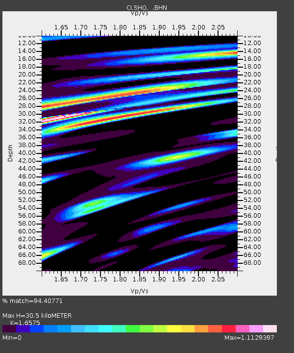
| Estimated Moho Depth: |
30.5 km |
| Estimated Crust Vp/Vs: |
1.66 |
| Assumed Crust Vp: |
6.276 km/s |
| Estimated Crust Vs: |
3.786 km/s |
| Estimated Crust Poisson's Ratio: |
0.21 |
|
| Radial Match: |
94.40771 % |
| Radial Bump: |
400 |
| Transverse Match: |
67.28903 % |
| Transverse Bump: |
400 |
| SOD ConfigId: |
2459 |
| Insert Time: |
2010-02-26 00:29:57.770 +0000 |
| GWidth: |
2.5 |
| Max Bumps: |
400 |
| Tol: |
0.001 |
|
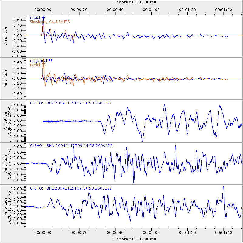
Signal To Noise
| Channel | StoN | STA | LTA |
| CI:SHO: :BHN:20041115T09:14:58.260012Z | 7.09095 | 1.910348E-6 | 2.694065E-7 |
| CI:SHO: :BHE:20041115T09:14:58.260012Z | 7.0456963 | 2.4782848E-6 | 3.517445E-7 |
| CI:SHO: :BHZ:20041115T09:14:58.260012Z | 19.47534 | 5.3575345E-6 | 2.7509324E-7 |
| Arrivals |
| Ps | 3.4 SECOND |
| PpPs | 12 SECOND |
| PsPs/PpSs | 16 SECOND |


