You are here: Home > Network List > CI - Caltech Regional Seismic Network Stations List
> Station MPM Manuel Prospect Mine, California, USA > Earthquake Result Viewer
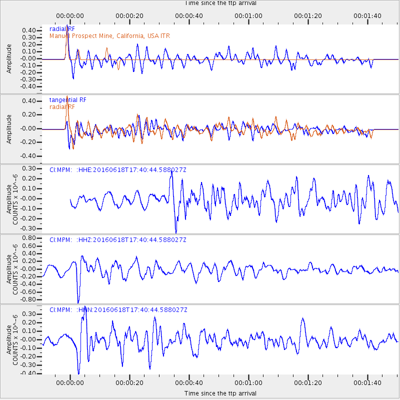
MPM Manuel Prospect Mine, California, USA - Earthquake Result Viewer
*The percent match for this event was below the threshold and hence no stack was calculated.
| Earthquake location: |
Chile-Argentina Border Region |
| Earthquake latitude/longitude: |
-24.2/-67.1 |
| Earthquake time(UTC): |
2016/06/18 (170) 17:29:44 GMT |
| Earthquake Depth: |
167 km |
| Earthquake Magnitude: |
5.5 MB |
| Earthquake Catalog/Contributor: |
NEIC PDE/NEIC COMCAT |
|
| Network: |
CI Caltech Regional Seismic Network |
| Station: |
MPM Manuel Prospect Mine, California, USA |
| Lat/Lon: |
36.06 N/117.49 W |
| Elevation: |
185 m |
|
| Distance: |
76.6 deg |
| Az: |
320.062 deg |
| Baz: |
133.666 deg |
| Ray Param: |
$rayparam |
*The percent match for this event was below the threshold and hence was not used in the summary stack. |
|
| Radial Match: |
60.918747 % |
| Radial Bump: |
400 |
| Transverse Match: |
66.72615 % |
| Transverse Bump: |
400 |
| SOD ConfigId: |
7422571 |
| Insert Time: |
2019-04-22 21:00:15.760 +0000 |
| GWidth: |
2.5 |
| Max Bumps: |
400 |
| Tol: |
0.001 |
|
Signal To Noise
| Channel | StoN | STA | LTA |
| CI:MPM: :HHZ:20160618T17:40:44.588027Z | 3.524512 | 3.513775E-7 | 9.9695356E-8 |
| CI:MPM: :HHN:20160618T17:40:44.588027Z | 4.0772977 | 1.9265362E-7 | 4.7250317E-8 |
| CI:MPM: :HHE:20160618T17:40:44.588027Z | 2.8390138 | 1.4778598E-7 | 5.205539E-8 |
| Arrivals |
| Ps | |
| PpPs | |
| PsPs/PpSs | |


