You are here: Home > Network List > US - United States National Seismic Network Stations List
> Station HWUT Hardware Ranch, Cache County, Utah, USA > Earthquake Result Viewer
HWUT Hardware Ranch, Cache County, Utah, USA - Earthquake Result Viewer
| Earthquake location: |
Fiji Islands Region |
| Earthquake latitude/longitude: |
-21.1/-176.6 |
| Earthquake time(UTC): |
2003/07/27 (208) 02:04:11 GMT |
| Earthquake Depth: |
213 km |
| Earthquake Magnitude: |
5.9 MB, 6.6 MW, 6.6 MW |
| Earthquake Catalog/Contributor: |
WHDF/NEIC |
|
| Network: |
US United States National Seismic Network |
| Station: |
HWUT Hardware Ranch, Cache County, Utah, USA |
| Lat/Lon: |
41.61 N/111.57 W |
| Elevation: |
1830 m |
|
| Distance: |
86.6 deg |
| Az: |
42.919 deg |
| Baz: |
237.996 deg |
| Ray Param: |
0.043423425 |
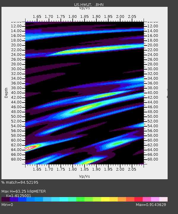
| Estimated Moho Depth: |
63.25 km |
| Estimated Crust Vp/Vs: |
1.61 |
| Assumed Crust Vp: |
6.155 km/s |
| Estimated Crust Vs: |
3.817 km/s |
| Estimated Crust Poisson's Ratio: |
0.19 |
|
| Radial Match: |
94.52195 % |
| Radial Bump: |
400 |
| Transverse Match: |
90.43636 % |
| Transverse Bump: |
400 |
| SOD ConfigId: |
110177 |
| Insert Time: |
2010-03-05 04:39:50.368 +0000 |
| GWidth: |
2.5 |
| Max Bumps: |
400 |
| Tol: |
0.001 |
|

Signal To Noise
| Channel | StoN | STA | LTA |
| US:HWUT: :BHN:20030727T02:15:59.454011Z | 2.1221933 | 7.380911E-8 | 3.4779635E-8 |
| US:HWUT: :BHE:20030727T02:15:59.454011Z | 3.690101 | 1.8200936E-7 | 4.932368E-8 |
| US:HWUT: :BHZ:20030727T02:15:59.454011Z | 13.412852 | 7.8315225E-7 | 5.83882E-8 |
| Arrivals |
| Ps | 6.4 SECOND |
| PpPs | 26 SECOND |
| PsPs/PpSs | 33 SECOND |


