You are here: Home > Network List > GS - US Geological Survey Networks Stations List
> Station KAN13 Rinehart Farm, , CA, USA > Earthquake Result Viewer
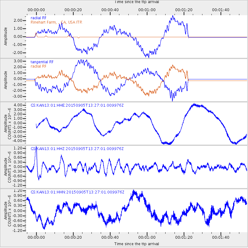
KAN13 Rinehart Farm, , CA, USA - Earthquake Result Viewer
*The percent match for this event was below the threshold and hence no stack was calculated.
| Earthquake location: |
Kuril Islands |
| Earthquake latitude/longitude: |
49.4/155.6 |
| Earthquake time(UTC): |
2015/09/05 (248) 13:16:10 GMT |
| Earthquake Depth: |
47 km |
| Earthquake Magnitude: |
5.9 MWB |
| Earthquake Catalog/Contributor: |
NEIC PDE/NEIC COMCAT |
|
| Network: |
GS US Geological Survey Networks |
| Station: |
KAN13 Rinehart Farm, , CA, USA |
| Lat/Lon: |
37.01 N/97.48 W |
| Elevation: |
340 m |
|
| Distance: |
72.5 deg |
| Az: |
53.448 deg |
| Baz: |
318.986 deg |
| Ray Param: |
$rayparam |
*The percent match for this event was below the threshold and hence was not used in the summary stack. |
|
| Radial Match: |
49.860382 % |
| Radial Bump: |
400 |
| Transverse Match: |
45.10874 % |
| Transverse Bump: |
400 |
| SOD ConfigId: |
1156111 |
| Insert Time: |
2015-09-19 13:34:13.323 +0000 |
| GWidth: |
2.5 |
| Max Bumps: |
400 |
| Tol: |
0.001 |
|
Signal To Noise
| Channel | StoN | STA | LTA |
| GS:KAN13:01:HHZ:20150905T13:27:01.009976Z | 7.565784 | 6.1692975E-7 | 8.154208E-8 |
| GS:KAN13:01:HHN:20150905T13:27:01.009976Z | 2.0007184 | 8.355598E-7 | 4.176299E-7 |
| GS:KAN13:01:HHE:20150905T13:27:01.009976Z | 1.2248726 | 1.5331955E-6 | 1.2517183E-6 |
| Arrivals |
| Ps | |
| PpPs | |
| PsPs/PpSs | |


