You are here: Home > Network List > TA - USArray Transportable Network (new EarthScope stations) Stations List
> Station MSTX Muleshoe, TX, USA > Earthquake Result Viewer
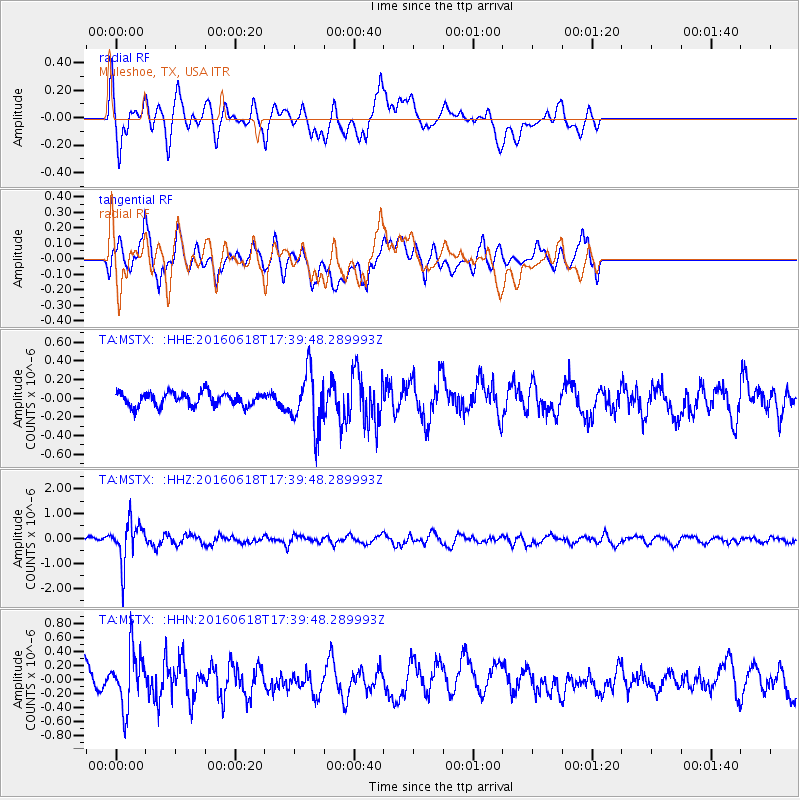
MSTX Muleshoe, TX, USA - Earthquake Result Viewer
*The percent match for this event was below the threshold and hence no stack was calculated.
| Earthquake location: |
Chile-Argentina Border Region |
| Earthquake latitude/longitude: |
-24.2/-67.1 |
| Earthquake time(UTC): |
2016/06/18 (170) 17:29:44 GMT |
| Earthquake Depth: |
167 km |
| Earthquake Magnitude: |
5.5 MB |
| Earthquake Catalog/Contributor: |
NEIC PDE/NEIC COMCAT |
|
| Network: |
TA USArray Transportable Network (new EarthScope stations) |
| Station: |
MSTX Muleshoe, TX, USA |
| Lat/Lon: |
33.97 N/102.77 W |
| Elevation: |
1167 m |
|
| Distance: |
67.1 deg |
| Az: |
328.24 deg |
| Baz: |
144.67 deg |
| Ray Param: |
$rayparam |
*The percent match for this event was below the threshold and hence was not used in the summary stack. |
|
| Radial Match: |
58.88879 % |
| Radial Bump: |
400 |
| Transverse Match: |
73.81165 % |
| Transverse Bump: |
400 |
| SOD ConfigId: |
7422571 |
| Insert Time: |
2019-04-22 21:06:41.772 +0000 |
| GWidth: |
2.5 |
| Max Bumps: |
400 |
| Tol: |
0.001 |
|
Signal To Noise
| Channel | StoN | STA | LTA |
| TA:MSTX: :HHZ:20160618T17:39:48.289993Z | 6.3433967 | 8.399073E-7 | 1.3240656E-7 |
| TA:MSTX: :HHN:20160618T17:39:48.289993Z | 1.8688874 | 3.9648407E-7 | 2.1214977E-7 |
| TA:MSTX: :HHE:20160618T17:39:48.289993Z | 4.267703 | 2.980183E-7 | 6.9831074E-8 |
| Arrivals |
| Ps | |
| PpPs | |
| PsPs/PpSs | |


