You are here: Home > Network List > US - United States National Seismic Network Stations List
> Station HWUT Hardware Ranch, Cache County, Utah, USA > Earthquake Result Viewer
HWUT Hardware Ranch, Cache County, Utah, USA - Earthquake Result Viewer
| Earthquake location: |
Southeast Of Honshu, Japan |
| Earthquake latitude/longitude: |
32.8/140.4 |
| Earthquake time(UTC): |
2009/08/12 (224) 22:48:51 GMT |
| Earthquake Depth: |
53 km |
| Earthquake Magnitude: |
6.2 MB, 6.6 MW, 6.6 MW |
| Earthquake Catalog/Contributor: |
WHDF/NEIC |
|
| Network: |
US United States National Seismic Network |
| Station: |
HWUT Hardware Ranch, Cache County, Utah, USA |
| Lat/Lon: |
41.61 N/111.57 W |
| Elevation: |
1830 m |
|
| Distance: |
80.7 deg |
| Az: |
46.263 deg |
| Baz: |
305.782 deg |
| Ray Param: |
0.04799265 |
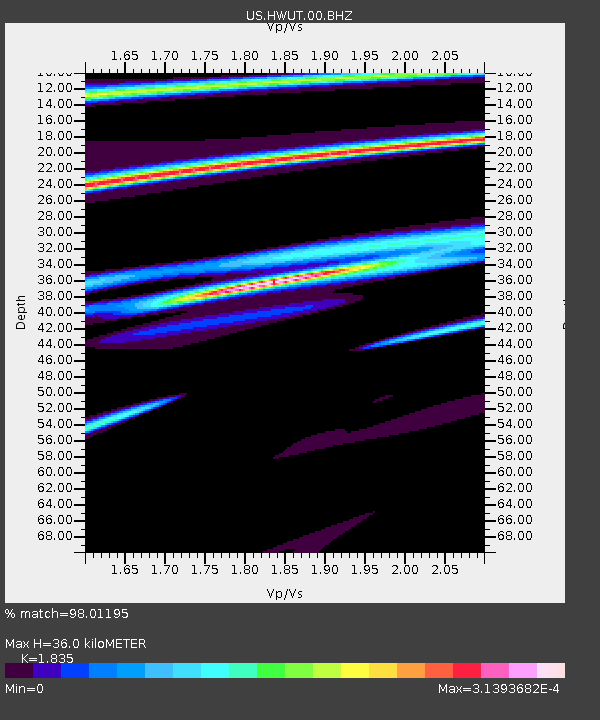
| Estimated Moho Depth: |
36.0 km |
| Estimated Crust Vp/Vs: |
1.84 |
| Assumed Crust Vp: |
6.155 km/s |
| Estimated Crust Vs: |
3.354 km/s |
| Estimated Crust Poisson's Ratio: |
0.29 |
|
| Radial Match: |
98.01195 % |
| Radial Bump: |
110 |
| Transverse Match: |
91.71738 % |
| Transverse Bump: |
85 |
| SOD ConfigId: |
2622 |
| Insert Time: |
2010-03-05 04:42:11.320 +0000 |
| GWidth: |
2.5 |
| Max Bumps: |
400 |
| Tol: |
0.001 |
|

Signal To Noise
| Channel | StoN | STA | LTA |
| US:HWUT:00:BHZ:20090812T23:00:27.901018Z | 0.3461084 | 7.968677E-6 | 2.3023646E-5 |
| US:HWUT:00:BHN:20090812T23:00:27.901018Z | 0.33747628 | 9.2678914E-7 | 2.746235E-6 |
| US:HWUT:00:BHE:20090812T23:00:27.901018Z | 0.45061752 | 6.438595E-7 | 1.4288381E-6 |
| Arrivals |
| Ps | 5.0 SECOND |
| PpPs | 16 SECOND |
| PsPs/PpSs | 21 SECOND |


