You are here: Home > Network List > TA - USArray Transportable Network (new EarthScope stations) Stations List
> Station H22K Ishtalitna Creek, AK, USA > Earthquake Result Viewer
H22K Ishtalitna Creek, AK, USA - Earthquake Result Viewer
| Earthquake location: |
Vanuatu Islands |
| Earthquake latitude/longitude: |
-20.3/169.1 |
| Earthquake time(UTC): |
2016/06/19 (171) 09:47:23 GMT |
| Earthquake Depth: |
13 km |
| Earthquake Magnitude: |
6.3 MWW, 6.2 MWB, 6.3 MWC, 6.6 MI |
| Earthquake Catalog/Contributor: |
NEIC PDE/NEIC COMCAT |
|
| Network: |
TA USArray Transportable Network (new EarthScope stations) |
| Station: |
H22K Ishtalitna Creek, AK, USA |
| Lat/Lon: |
65.89 N/151.38 W |
| Elevation: |
561 m |
|
| Distance: |
91.0 deg |
| Az: |
15.162 deg |
| Baz: |
216.713 deg |
| Ray Param: |
0.04163526 |
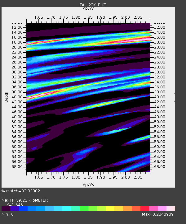
| Estimated Moho Depth: |
39.25 km |
| Estimated Crust Vp/Vs: |
1.64 |
| Assumed Crust Vp: |
6.566 km/s |
| Estimated Crust Vs: |
3.992 km/s |
| Estimated Crust Poisson's Ratio: |
0.21 |
|
| Radial Match: |
83.83382 % |
| Radial Bump: |
400 |
| Transverse Match: |
51.16979 % |
| Transverse Bump: |
400 |
| SOD ConfigId: |
7422571 |
| Insert Time: |
2019-04-22 21:14:56.830 +0000 |
| GWidth: |
2.5 |
| Max Bumps: |
400 |
| Tol: |
0.001 |
|

Signal To Noise
| Channel | StoN | STA | LTA |
| TA:H22K: :BHZ:20160619T09:59:55.600Z | 6.564359 | 4.5301533E-7 | 6.901136E-8 |
| TA:H22K: :BHN:20160619T09:59:55.600Z | 2.0239959 | 1.5298262E-7 | 7.558445E-8 |
| TA:H22K: :BHE:20160619T09:59:55.600Z | 1.246248 | 8.054031E-8 | 6.4626235E-8 |
| Arrivals |
| Ps | 3.9 SECOND |
| PpPs | 15 SECOND |
| PsPs/PpSs | 19 SECOND |


