You are here: Home > Network List > TA - USArray Transportable Network (new EarthScope stations) Stations List
> Station M19K Big River Lodge, Big River, AK, USA > Earthquake Result Viewer
M19K Big River Lodge, Big River, AK, USA - Earthquake Result Viewer
| Earthquake location: |
Vanuatu Islands |
| Earthquake latitude/longitude: |
-20.3/169.1 |
| Earthquake time(UTC): |
2016/06/19 (171) 09:47:23 GMT |
| Earthquake Depth: |
13 km |
| Earthquake Magnitude: |
6.3 MWW, 6.2 MWB, 6.3 MWC, 6.6 MI |
| Earthquake Catalog/Contributor: |
NEIC PDE/NEIC COMCAT |
|
| Network: |
TA USArray Transportable Network (new EarthScope stations) |
| Station: |
M19K Big River Lodge, Big River, AK, USA |
| Lat/Lon: |
61.90 N/154.39 W |
| Elevation: |
521 m |
|
| Distance: |
86.9 deg |
| Az: |
16.393 deg |
| Baz: |
214.031 deg |
| Ray Param: |
0.043689035 |
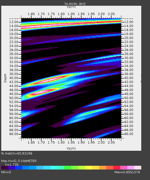
| Estimated Moho Depth: |
41.0 km |
| Estimated Crust Vp/Vs: |
1.74 |
| Assumed Crust Vp: |
6.566 km/s |
| Estimated Crust Vs: |
3.785 km/s |
| Estimated Crust Poisson's Ratio: |
0.25 |
|
| Radial Match: |
80.93196 % |
| Radial Bump: |
400 |
| Transverse Match: |
58.015804 % |
| Transverse Bump: |
400 |
| SOD ConfigId: |
7422571 |
| Insert Time: |
2019-04-22 21:15:13.588 +0000 |
| GWidth: |
2.5 |
| Max Bumps: |
400 |
| Tol: |
0.001 |
|

Signal To Noise
| Channel | StoN | STA | LTA |
| TA:M19K: :BHZ:20160619T09:59:36.600Z | 3.7463162 | 6.380168E-7 | 1.7030511E-7 |
| TA:M19K: :BHN:20160619T09:59:36.600Z | 1.5938396 | 2.2162595E-7 | 1.3905161E-7 |
| TA:M19K: :BHE:20160619T09:59:36.600Z | 0.6595641 | 1.2263096E-7 | 1.8592729E-7 |
| Arrivals |
| Ps | 4.7 SECOND |
| PpPs | 17 SECOND |
| PsPs/PpSs | 21 SECOND |


