You are here: Home > Network List > TA - USArray Transportable Network (new EarthScope stations) Stations List
> Station N16K Nishlik Lake, AK, USA > Earthquake Result Viewer
N16K Nishlik Lake, AK, USA - Earthquake Result Viewer
| Earthquake location: |
Vanuatu Islands |
| Earthquake latitude/longitude: |
-20.3/169.1 |
| Earthquake time(UTC): |
2016/06/19 (171) 09:47:23 GMT |
| Earthquake Depth: |
13 km |
| Earthquake Magnitude: |
6.3 MWW, 6.2 MWB, 6.3 MWC, 6.6 MI |
| Earthquake Catalog/Contributor: |
NEIC PDE/NEIC COMCAT |
|
| Network: |
TA USArray Transportable Network (new EarthScope stations) |
| Station: |
N16K Nishlik Lake, AK, USA |
| Lat/Lon: |
60.47 N/158.77 W |
| Elevation: |
582 m |
|
| Distance: |
84.6 deg |
| Az: |
15.355 deg |
| Baz: |
210.124 deg |
| Ray Param: |
0.04537076 |
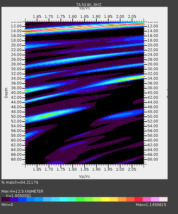
| Estimated Moho Depth: |
12.5 km |
| Estimated Crust Vp/Vs: |
1.81 |
| Assumed Crust Vp: |
6.276 km/s |
| Estimated Crust Vs: |
3.477 km/s |
| Estimated Crust Poisson's Ratio: |
0.28 |
|
| Radial Match: |
84.21176 % |
| Radial Bump: |
400 |
| Transverse Match: |
51.347378 % |
| Transverse Bump: |
400 |
| SOD ConfigId: |
7422571 |
| Insert Time: |
2019-04-22 21:15:22.085 +0000 |
| GWidth: |
2.5 |
| Max Bumps: |
400 |
| Tol: |
0.001 |
|

Signal To Noise
| Channel | StoN | STA | LTA |
| TA:N16K: :BHZ:20160619T09:59:25.024988Z | 4.5782986 | 8.966101E-7 | 1.9583916E-7 |
| TA:N16K: :BHN:20160619T09:59:25.024988Z | 0.87602276 | 2.8517334E-7 | 3.2553191E-7 |
| TA:N16K: :BHE:20160619T09:59:25.024988Z | 0.77338463 | 1.7098942E-7 | 2.2109235E-7 |
| Arrivals |
| Ps | 1.6 SECOND |
| PpPs | 5.5 SECOND |
| PsPs/PpSs | 7.1 SECOND |


