You are here: Home > Network List > YT07 - POLENET Stations List
> Station WAWA WAWA > Earthquake Result Viewer
WAWA WAWA - Earthquake Result Viewer
| Earthquake location: |
Vanuatu Islands |
| Earthquake latitude/longitude: |
-20.3/169.1 |
| Earthquake time(UTC): |
2016/06/19 (171) 09:47:23 GMT |
| Earthquake Depth: |
13 km |
| Earthquake Magnitude: |
6.3 MWW, 6.2 MWB, 6.3 MWC, 6.6 MI |
| Earthquake Catalog/Contributor: |
NEIC PDE/NEIC COMCAT |
|
| Network: |
YT POLENET |
| Station: |
WAWA WAWA |
| Lat/Lon: |
81.58 S/28.42 W |
| Elevation: |
1202 m |
|
| Distance: |
77.9 deg |
| Az: |
177.402 deg |
| Baz: |
196.773 deg |
| Ray Param: |
0.049970165 |
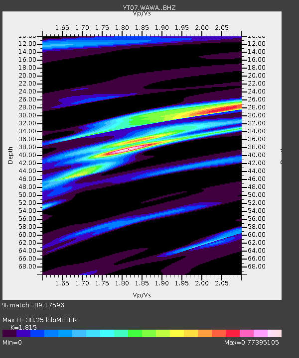
| Estimated Moho Depth: |
38.25 km |
| Estimated Crust Vp/Vs: |
1.82 |
| Assumed Crust Vp: |
6.424 km/s |
| Estimated Crust Vs: |
3.539 km/s |
| Estimated Crust Poisson's Ratio: |
0.28 |
|
| Radial Match: |
89.17596 % |
| Radial Bump: |
299 |
| Transverse Match: |
68.458015 % |
| Transverse Bump: |
400 |
| SOD ConfigId: |
7422571 |
| Insert Time: |
2019-04-22 21:17:27.644 +0000 |
| GWidth: |
2.5 |
| Max Bumps: |
400 |
| Tol: |
0.001 |
|

Signal To Noise
| Channel | StoN | STA | LTA |
| YT:WAWA: :BHZ:20160619T09:58:49.923975Z | 3.7392569 | 9.4619077E-7 | 2.5304246E-7 |
| YT:WAWA: :BHN:20160619T09:58:49.923975Z | 3.0172102 | 3.4674719E-7 | 1.1492311E-7 |
| YT:WAWA: :BHE:20160619T09:58:49.923975Z | 0.966243 | 1.9188644E-7 | 1.9859024E-7 |
| Arrivals |
| Ps | 5.0 SECOND |
| PpPs | 16 SECOND |
| PsPs/PpSs | 21 SECOND |


