You are here: Home > Network List > KN - Kyrgyz Seismic Telemetry Network Stations List
> Station CHM KN.CHM > Earthquake Result Viewer
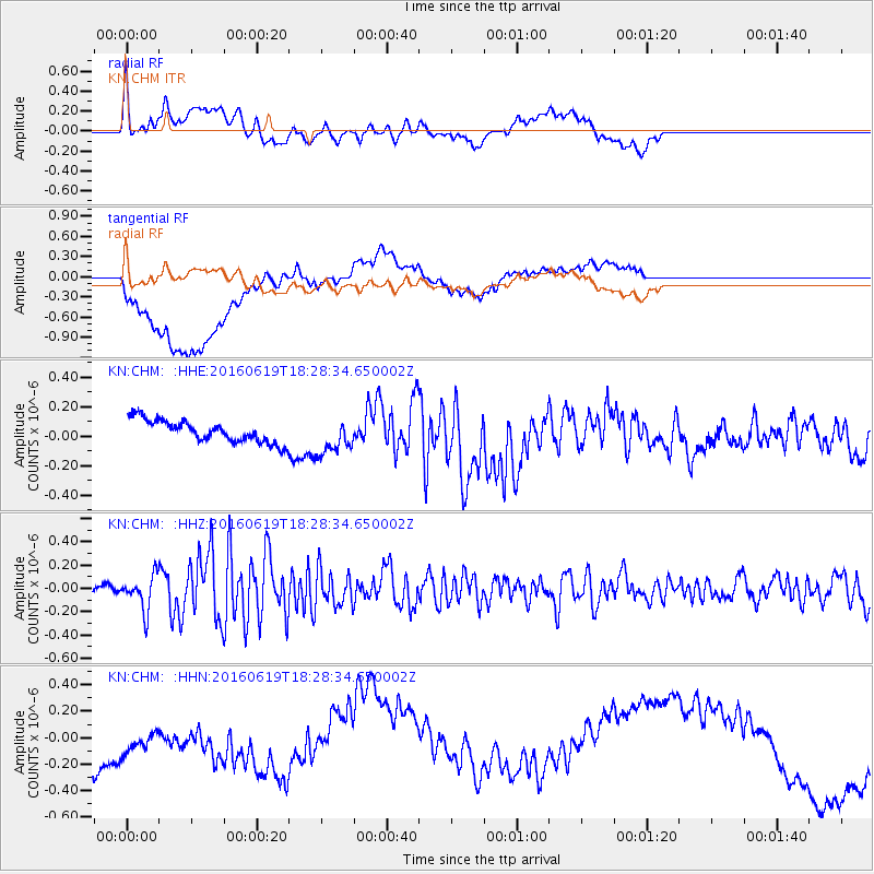
CHM KN.CHM - Earthquake Result Viewer
*The percent match for this event was below the threshold and hence no stack was calculated.
| Earthquake location: |
Philippine Islands Region |
| Earthquake latitude/longitude: |
20.1/121.4 |
| Earthquake time(UTC): |
2016/06/19 (171) 18:20:50 GMT |
| Earthquake Depth: |
18 km |
| Earthquake Magnitude: |
5.6 MWW, 5.4 MWB |
| Earthquake Catalog/Contributor: |
NEIC PDE/NEIC COMCAT |
|
| Network: |
KN Kyrgyz Seismic Telemetry Network |
| Station: |
CHM KN.CHM |
| Lat/Lon: |
43.00 N/74.75 E |
| Elevation: |
655 m |
|
| Distance: |
45.1 deg |
| Az: |
311.146 deg |
| Baz: |
105.327 deg |
| Ray Param: |
$rayparam |
*The percent match for this event was below the threshold and hence was not used in the summary stack. |
|
| Radial Match: |
64.887665 % |
| Radial Bump: |
400 |
| Transverse Match: |
24.115732 % |
| Transverse Bump: |
400 |
| SOD ConfigId: |
7422571 |
| Insert Time: |
2019-04-22 21:20:25.413 +0000 |
| GWidth: |
2.5 |
| Max Bumps: |
400 |
| Tol: |
0.001 |
|
Signal To Noise
| Channel | StoN | STA | LTA |
| KN:CHM: :HHZ:20160619T18:28:34.650002Z | 4.0937166 | 1.5050303E-7 | 3.6764398E-8 |
| KN:CHM: :HHN:20160619T18:28:34.650002Z | 0.7721728 | 2.5424325E-7 | 3.2925692E-7 |
| KN:CHM: :HHE:20160619T18:28:34.650002Z | 1.4651618 | 1.1204577E-7 | 7.6473306E-8 |
| Arrivals |
| Ps | |
| PpPs | |
| PsPs/PpSs | |


