You are here: Home > Network List > KR - Kyrgyz Digital Network Stations List
> Station ARLS Aral, Kyrgyzstan > Earthquake Result Viewer
ARLS Aral, Kyrgyzstan - Earthquake Result Viewer
| Earthquake location: |
Philippine Islands Region |
| Earthquake latitude/longitude: |
20.1/121.4 |
| Earthquake time(UTC): |
2016/06/19 (171) 18:20:50 GMT |
| Earthquake Depth: |
18 km |
| Earthquake Magnitude: |
5.6 MWW, 5.4 MWB |
| Earthquake Catalog/Contributor: |
NEIC PDE/NEIC COMCAT |
|
| Network: |
KR Kyrgyz Digital Network |
| Station: |
ARLS Aral, Kyrgyzstan |
| Lat/Lon: |
41.87 N/74.33 E |
| Elevation: |
1526 m |
|
| Distance: |
45.1 deg |
| Az: |
309.494 deg |
| Baz: |
103.878 deg |
| Ray Param: |
0.071465045 |
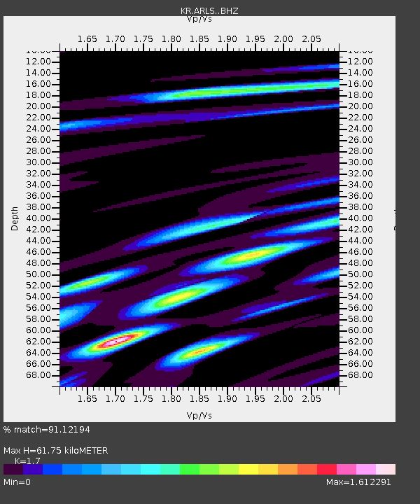
| Estimated Moho Depth: |
61.75 km |
| Estimated Crust Vp/Vs: |
1.70 |
| Assumed Crust Vp: |
6.491 km/s |
| Estimated Crust Vs: |
3.818 km/s |
| Estimated Crust Poisson's Ratio: |
0.24 |
|
| Radial Match: |
91.12194 % |
| Radial Bump: |
400 |
| Transverse Match: |
73.41392 % |
| Transverse Bump: |
400 |
| SOD ConfigId: |
7422571 |
| Insert Time: |
2019-04-22 21:20:32.523 +0000 |
| GWidth: |
2.5 |
| Max Bumps: |
400 |
| Tol: |
0.001 |
|

Signal To Noise
| Channel | StoN | STA | LTA |
| KR:ARLS: :BHZ:20160619T18:28:34.775002Z | 3.1044672 | 1.3323827E-7 | 4.2918245E-8 |
| KR:ARLS: :BHN:20160619T18:28:34.775002Z | 0.9172695 | 3.0723537E-8 | 3.349456E-8 |
| KR:ARLS: :BHE:20160619T18:28:34.775002Z | 2.7326617 | 7.63509E-8 | 2.7940121E-8 |
| Arrivals |
| Ps | 7.1 SECOND |
| PpPs | 24 SECOND |
| PsPs/PpSs | 31 SECOND |


