You are here: Home > Network List > TA - USArray Transportable Network (new EarthScope stations) Stations List
> Station J20K Nowitna River, AK, USA > Earthquake Result Viewer
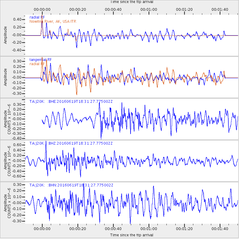
J20K Nowitna River, AK, USA - Earthquake Result Viewer
*The percent match for this event was below the threshold and hence no stack was calculated.
| Earthquake location: |
Philippine Islands Region |
| Earthquake latitude/longitude: |
20.1/121.4 |
| Earthquake time(UTC): |
2016/06/19 (171) 18:20:50 GMT |
| Earthquake Depth: |
18 km |
| Earthquake Magnitude: |
5.6 MWW, 5.4 MWB |
| Earthquake Catalog/Contributor: |
NEIC PDE/NEIC COMCAT |
|
| Network: |
TA USArray Transportable Network (new EarthScope stations) |
| Station: |
J20K Nowitna River, AK, USA |
| Lat/Lon: |
64.18 N/154.15 W |
| Elevation: |
314 m |
|
| Distance: |
69.7 deg |
| Az: |
27.703 deg |
| Baz: |
274.18 deg |
| Ray Param: |
$rayparam |
*The percent match for this event was below the threshold and hence was not used in the summary stack. |
|
| Radial Match: |
61.58805 % |
| Radial Bump: |
400 |
| Transverse Match: |
66.46531 % |
| Transverse Bump: |
400 |
| SOD ConfigId: |
7422571 |
| Insert Time: |
2019-04-22 21:21:46.836 +0000 |
| GWidth: |
2.5 |
| Max Bumps: |
400 |
| Tol: |
0.001 |
|
Signal To Noise
| Channel | StoN | STA | LTA |
| TA:J20K: :BHZ:20160619T18:31:27.775002Z | 2.747085 | 2.5761318E-7 | 9.377692E-8 |
| TA:J20K: :BHN:20160619T18:31:27.775002Z | 1.474078 | 8.508687E-8 | 5.772209E-8 |
| TA:J20K: :BHE:20160619T18:31:27.775002Z | 1.9368174 | 1.7069715E-7 | 8.81328E-8 |
| Arrivals |
| Ps | |
| PpPs | |
| PsPs/PpSs | |


