You are here: Home > Network List > US - United States National Seismic Network Stations List
> Station CBKS Cedar Bluff, Kansas, USA > Earthquake Result Viewer
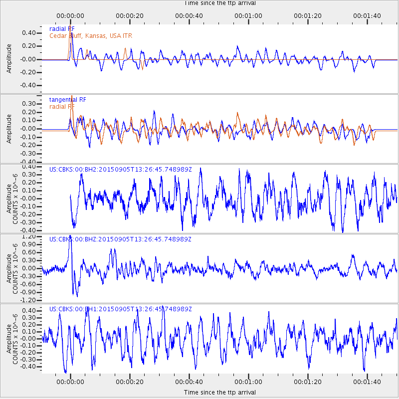
CBKS Cedar Bluff, Kansas, USA - Earthquake Result Viewer
*The percent match for this event was below the threshold and hence no stack was calculated.
| Earthquake location: |
Kuril Islands |
| Earthquake latitude/longitude: |
49.4/155.6 |
| Earthquake time(UTC): |
2015/09/05 (248) 13:16:10 GMT |
| Earthquake Depth: |
47 km |
| Earthquake Magnitude: |
5.9 MWB |
| Earthquake Catalog/Contributor: |
NEIC PDE/NEIC COMCAT |
|
| Network: |
US United States National Seismic Network |
| Station: |
CBKS Cedar Bluff, Kansas, USA |
| Lat/Lon: |
38.81 N/99.74 W |
| Elevation: |
677 m |
|
| Distance: |
69.9 deg |
| Az: |
53.595 deg |
| Baz: |
317.65 deg |
| Ray Param: |
$rayparam |
*The percent match for this event was below the threshold and hence was not used in the summary stack. |
|
| Radial Match: |
61.093906 % |
| Radial Bump: |
400 |
| Transverse Match: |
66.95081 % |
| Transverse Bump: |
400 |
| SOD ConfigId: |
1156111 |
| Insert Time: |
2015-09-19 13:40:05.124 +0000 |
| GWidth: |
2.5 |
| Max Bumps: |
400 |
| Tol: |
0.001 |
|
Signal To Noise
| Channel | StoN | STA | LTA |
| US:CBKS:00:BHZ:20150905T13:26:45.748989Z | 7.66541 | 6.8564754E-7 | 8.944695E-8 |
| US:CBKS:00:BH1:20150905T13:26:45.748989Z | 1.5349284 | 1.4250021E-7 | 9.283834E-8 |
| US:CBKS:00:BH2:20150905T13:26:45.748989Z | 0.9053385 | 1.1640221E-7 | 1.2857313E-7 |
| Arrivals |
| Ps | |
| PpPs | |
| PsPs/PpSs | |


