You are here: Home > Network List > US - United States National Seismic Network Stations List
> Station EGMT Eagleton, Montana, USA > Earthquake Result Viewer
EGMT Eagleton, Montana, USA - Earthquake Result Viewer
*The percent match for this event was below the threshold and hence no stack was calculated.
| Earthquake location: |
Kuril Islands |
| Earthquake latitude/longitude: |
49.4/155.6 |
| Earthquake time(UTC): |
2015/09/05 (248) 13:16:10 GMT |
| Earthquake Depth: |
47 km |
| Earthquake Magnitude: |
5.9 MWB |
| Earthquake Catalog/Contributor: |
NEIC PDE/NEIC COMCAT |
|
| Network: |
US United States National Seismic Network |
| Station: |
EGMT Eagleton, Montana, USA |
| Lat/Lon: |
48.02 N/109.75 W |
| Elevation: |
1055 m |
|
| Distance: |
58.3 deg |
| Az: |
51.858 deg |
| Baz: |
309.995 deg |
| Ray Param: |
$rayparam |
*The percent match for this event was below the threshold and hence was not used in the summary stack. |
|
| Radial Match: |
63.696404 % |
| Radial Bump: |
400 |
| Transverse Match: |
54.473118 % |
| Transverse Bump: |
400 |
| SOD ConfigId: |
1156111 |
| Insert Time: |
2015-09-19 13:40:27.369 +0000 |
| GWidth: |
2.5 |
| Max Bumps: |
400 |
| Tol: |
0.001 |
|
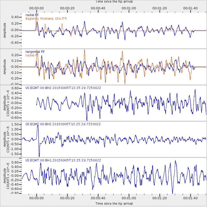
Signal To Noise
| Channel | StoN | STA | LTA |
| US:EGMT:00:BHZ:20150905T13:25:29.725002Z | 6.6717033 | 7.6249245E-7 | 1.14287516E-7 |
| US:EGMT:00:BH1:20150905T13:25:29.725002Z | 2.11449 | 2.7077581E-7 | 1.2805727E-7 |
| US:EGMT:00:BH2:20150905T13:25:29.725002Z | 2.039975 | 2.9486003E-7 | 1.44541E-7 |
| Arrivals |
| Ps | |
| PpPs | |
| PsPs/PpSs | |


