You are here: Home > Network List > CI - Caltech Regional Seismic Network Stations List
> Station SHO Shoshone, CA, USA > Earthquake Result Viewer
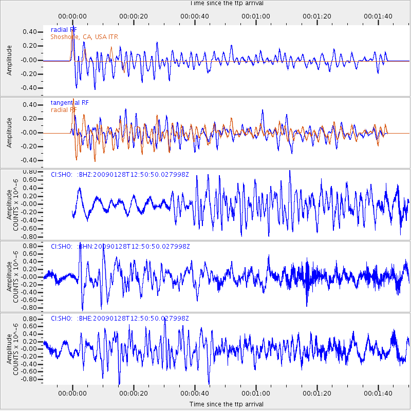
SHO Shoshone, CA, USA - Earthquake Result Viewer
*The percent match for this event was below the threshold and hence no stack was calculated.
| Earthquake location: |
Samoa Islands Region |
| Earthquake latitude/longitude: |
-17.0/-172.1 |
| Earthquake time(UTC): |
2009/01/28 (028) 12:39:42 GMT |
| Earthquake Depth: |
10 km |
| Earthquake Magnitude: |
5.6 MB, 5.3 MS, 5.5 MW |
| Earthquake Catalog/Contributor: |
WHDF/NEIC |
|
| Network: |
CI Caltech Regional Seismic Network |
| Station: |
SHO Shoshone, CA, USA |
| Lat/Lon: |
35.90 N/116.28 W |
| Elevation: |
451 m |
|
| Distance: |
74.5 deg |
| Az: |
44.174 deg |
| Baz: |
235.221 deg |
| Ray Param: |
$rayparam |
*The percent match for this event was below the threshold and hence was not used in the summary stack. |
|
| Radial Match: |
69.12514 % |
| Radial Bump: |
400 |
| Transverse Match: |
65.60813 % |
| Transverse Bump: |
400 |
| SOD ConfigId: |
2658 |
| Insert Time: |
2010-02-26 00:30:31.222 +0000 |
| GWidth: |
2.5 |
| Max Bumps: |
400 |
| Tol: |
0.001 |
|
Signal To Noise
| Channel | StoN | STA | LTA |
| CI:SHO: :BHN:20090128T12:50:50.027998Z | 2.7804205 | 3.7374096E-7 | 1.3441885E-7 |
| CI:SHO: :BHE:20090128T12:50:50.027998Z | 1.9210826 | 1.9930103E-7 | 1.0374412E-7 |
| CI:SHO: :BHZ:20090128T12:50:50.027998Z | 1.1418706 | 1.8231268E-7 | 1.5966141E-7 |
| Arrivals |
| Ps | |
| PpPs | |
| PsPs/PpSs | |


