You are here: Home > Network List > US - United States National Seismic Network Stations List
> Station MIAR Mount Ida, Arkansas, USA > Earthquake Result Viewer
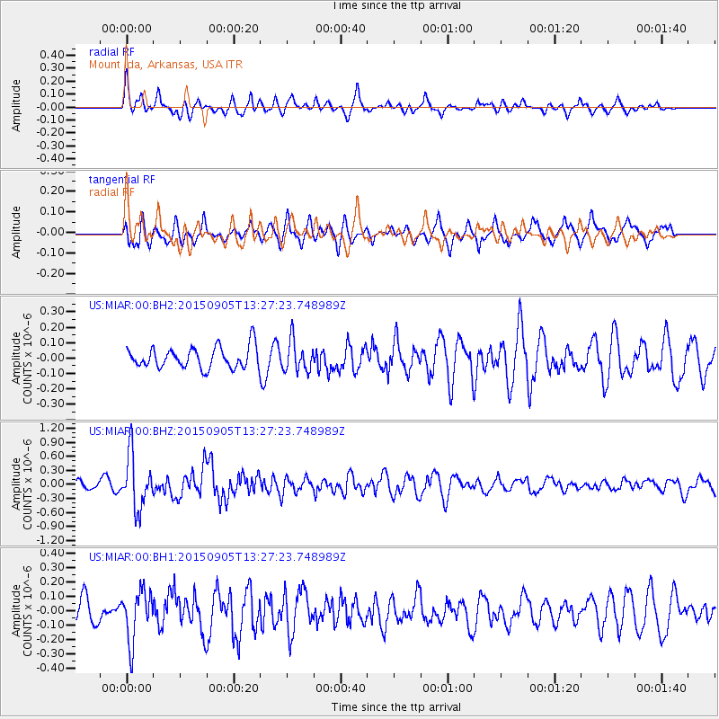
MIAR Mount Ida, Arkansas, USA - Earthquake Result Viewer
*The percent match for this event was below the threshold and hence no stack was calculated.
| Earthquake location: |
Kuril Islands |
| Earthquake latitude/longitude: |
49.4/155.6 |
| Earthquake time(UTC): |
2015/09/05 (248) 13:16:10 GMT |
| Earthquake Depth: |
47 km |
| Earthquake Magnitude: |
5.9 MWB |
| Earthquake Catalog/Contributor: |
NEIC PDE/NEIC COMCAT |
|
| Network: |
US United States National Seismic Network |
| Station: |
MIAR Mount Ida, Arkansas, USA |
| Lat/Lon: |
34.55 N/93.58 W |
| Elevation: |
207 m |
|
| Distance: |
76.4 deg |
| Az: |
52.567 deg |
| Baz: |
321.021 deg |
| Ray Param: |
$rayparam |
*The percent match for this event was below the threshold and hence was not used in the summary stack. |
|
| Radial Match: |
59.826138 % |
| Radial Bump: |
400 |
| Transverse Match: |
72.3453 % |
| Transverse Bump: |
400 |
| SOD ConfigId: |
1156111 |
| Insert Time: |
2015-09-19 13:41:40.967 +0000 |
| GWidth: |
2.5 |
| Max Bumps: |
400 |
| Tol: |
0.001 |
|
Signal To Noise
| Channel | StoN | STA | LTA |
| US:MIAR:00:BHZ:20150905T13:27:23.748989Z | 4.724022 | 5.8259707E-7 | 1.2332649E-7 |
| US:MIAR:00:BH1:20150905T13:27:23.748989Z | 2.3060887 | 1.755947E-7 | 7.6143955E-8 |
| US:MIAR:00:BH2:20150905T13:27:23.748989Z | 1.4736848 | 1.0034134E-7 | 6.808874E-8 |
| Arrivals |
| Ps | |
| PpPs | |
| PsPs/PpSs | |


