You are here: Home > Network List > TA - USArray Transportable Network (new EarthScope stations) Stations List
> Station I23K Minto, Yukon-Koyukuk, AK, USA > Earthquake Result Viewer
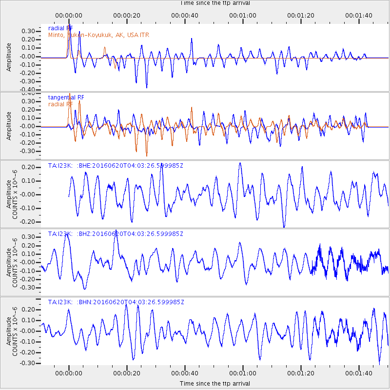
I23K Minto, Yukon-Koyukuk, AK, USA - Earthquake Result Viewer
*The percent match for this event was below the threshold and hence no stack was calculated.
| Earthquake location: |
Loyalty Islands |
| Earthquake latitude/longitude: |
-20.2/168.8 |
| Earthquake time(UTC): |
2016/06/20 (172) 03:50:55 GMT |
| Earthquake Depth: |
15 km |
| Earthquake Magnitude: |
6.0 MWW, 5.8 MWB, 5.9 MWC, 6.0 MWC |
| Earthquake Catalog/Contributor: |
NEIC PDE/NEIC COMCAT |
|
| Network: |
TA USArray Transportable Network (new EarthScope stations) |
| Station: |
I23K Minto, Yukon-Koyukuk, AK, USA |
| Lat/Lon: |
65.15 N/149.36 W |
| Elevation: |
149 m |
|
| Distance: |
90.9 deg |
| Az: |
16.389 deg |
| Baz: |
218.834 deg |
| Ray Param: |
$rayparam |
*The percent match for this event was below the threshold and hence was not used in the summary stack. |
|
| Radial Match: |
67.831825 % |
| Radial Bump: |
346 |
| Transverse Match: |
55.288364 % |
| Transverse Bump: |
400 |
| SOD ConfigId: |
7422571 |
| Insert Time: |
2019-04-22 21:28:43.953 +0000 |
| GWidth: |
2.5 |
| Max Bumps: |
400 |
| Tol: |
0.001 |
|
Signal To Noise
| Channel | StoN | STA | LTA |
| TA:I23K: :BHZ:20160620T04:03:26.599985Z | 2.3660743 | 2.0484596E-7 | 8.65763E-8 |
| TA:I23K: :BHN:20160620T04:03:26.599985Z | 2.0575042 | 1.0207798E-7 | 4.9612527E-8 |
| TA:I23K: :BHE:20160620T04:03:26.599985Z | 1.2506006 | 1.14889815E-7 | 9.186771E-8 |
| Arrivals |
| Ps | |
| PpPs | |
| PsPs/PpSs | |


