You are here: Home > Network List > TA - USArray Transportable Network (new EarthScope stations) Stations List
> Station O17K Koliganek, Bristol Bay, AK, USA > Earthquake Result Viewer
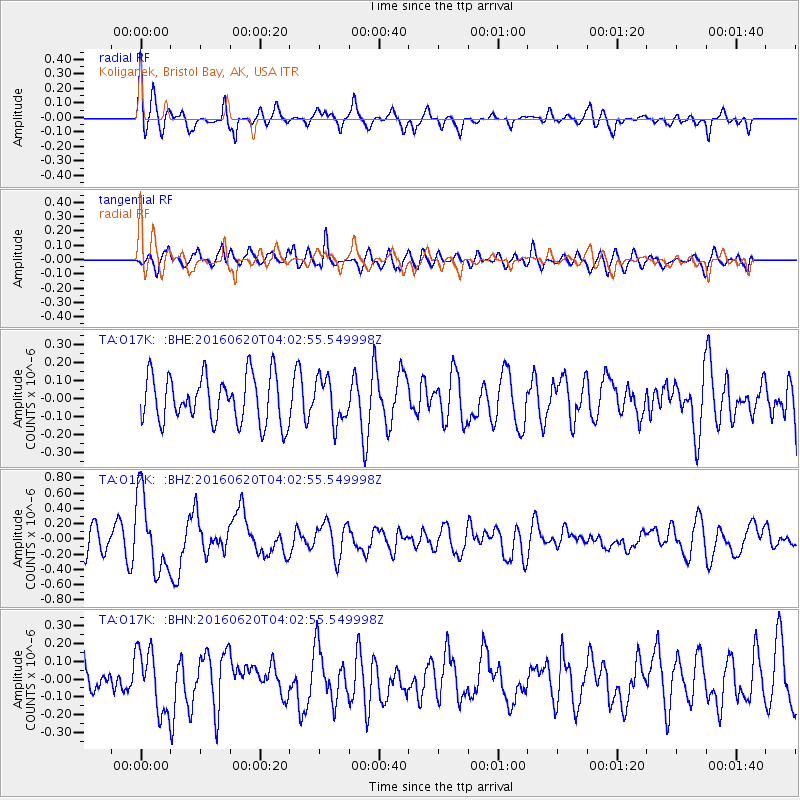
O17K Koliganek, Bristol Bay, AK, USA - Earthquake Result Viewer
*The percent match for this event was below the threshold and hence no stack was calculated.
| Earthquake location: |
Loyalty Islands |
| Earthquake latitude/longitude: |
-20.2/168.8 |
| Earthquake time(UTC): |
2016/06/20 (172) 03:50:55 GMT |
| Earthquake Depth: |
15 km |
| Earthquake Magnitude: |
6.0 MWW, 5.8 MWB, 5.9 MWC, 6.0 MWC |
| Earthquake Catalog/Contributor: |
NEIC PDE/NEIC COMCAT |
|
| Network: |
TA USArray Transportable Network (new EarthScope stations) |
| Station: |
O17K Koliganek, Bristol Bay, AK, USA |
| Lat/Lon: |
59.77 N/157.09 W |
| Elevation: |
156 m |
|
| Distance: |
84.4 deg |
| Az: |
16.579 deg |
| Baz: |
211.984 deg |
| Ray Param: |
$rayparam |
*The percent match for this event was below the threshold and hence was not used in the summary stack. |
|
| Radial Match: |
69.24189 % |
| Radial Bump: |
400 |
| Transverse Match: |
54.784813 % |
| Transverse Bump: |
400 |
| SOD ConfigId: |
7422571 |
| Insert Time: |
2019-04-22 21:29:03.925 +0000 |
| GWidth: |
2.5 |
| Max Bumps: |
400 |
| Tol: |
0.001 |
|
Signal To Noise
| Channel | StoN | STA | LTA |
| TA:O17K: :BHZ:20160620T04:02:55.549998Z | 2.6106734 | 4.9810615E-7 | 1.9079604E-7 |
| TA:O17K: :BHN:20160620T04:02:55.549998Z | 1.4422499 | 1.7687418E-7 | 1.2263769E-7 |
| TA:O17K: :BHE:20160620T04:02:55.549998Z | 0.92487985 | 1.2138662E-7 | 1.3124583E-7 |
| Arrivals |
| Ps | |
| PpPs | |
| PsPs/PpSs | |


