You are here: Home > Network List > UW - Pacific Northwest Regional Seismic Network Stations List
> Station YACT Amboy, WA, USA > Earthquake Result Viewer
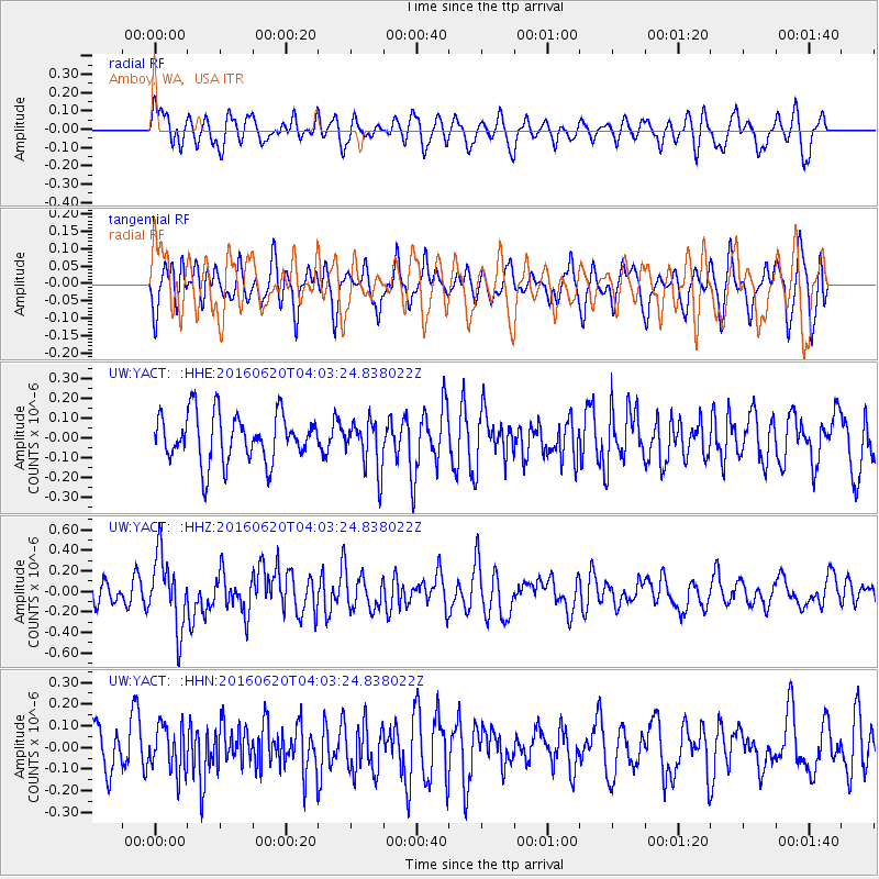
YACT Amboy, WA, USA - Earthquake Result Viewer
*The percent match for this event was below the threshold and hence no stack was calculated.
| Earthquake location: |
Loyalty Islands |
| Earthquake latitude/longitude: |
-20.2/168.8 |
| Earthquake time(UTC): |
2016/06/20 (172) 03:50:55 GMT |
| Earthquake Depth: |
15 km |
| Earthquake Magnitude: |
6.0 MWW, 5.8 MWB, 5.9 MWC, 6.0 MWC |
| Earthquake Catalog/Contributor: |
NEIC PDE/NEIC COMCAT |
|
| Network: |
UW Pacific Northwest Regional Seismic Network |
| Station: |
YACT Amboy, WA, USA |
| Lat/Lon: |
45.93 N/122.42 W |
| Elevation: |
211 m |
|
| Distance: |
90.5 deg |
| Az: |
40.602 deg |
| Baz: |
241.14 deg |
| Ray Param: |
$rayparam |
*The percent match for this event was below the threshold and hence was not used in the summary stack. |
|
| Radial Match: |
46.975483 % |
| Radial Bump: |
400 |
| Transverse Match: |
52.41618 % |
| Transverse Bump: |
400 |
| SOD ConfigId: |
7422571 |
| Insert Time: |
2019-04-22 21:29:47.330 +0000 |
| GWidth: |
2.5 |
| Max Bumps: |
400 |
| Tol: |
0.001 |
|
Signal To Noise
| Channel | StoN | STA | LTA |
| UW:YACT: :HHZ:20160620T04:03:24.838022Z | 3.2110336 | 3.4876658E-7 | 1.0861505E-7 |
| UW:YACT: :HHN:20160620T04:03:24.838022Z | 0.9161894 | 1.0598479E-7 | 1.15679995E-7 |
| UW:YACT: :HHE:20160620T04:03:24.838022Z | 1.0508965 | 1.2783335E-7 | 1.2164219E-7 |
| Arrivals |
| Ps | |
| PpPs | |
| PsPs/PpSs | |


