You are here: Home > Network List > 7A - Mid-Atlantic Geophysical Integrative Collaboration Stations List
> Station FOXP Brandywine, West Virginia USA > Earthquake Result Viewer
FOXP Brandywine, West Virginia USA - Earthquake Result Viewer
| Earthquake location: |
Northern Mid-Atlantic Ridge |
| Earthquake latitude/longitude: |
22.7/-45.1 |
| Earthquake time(UTC): |
2016/06/21 (173) 16:26:34 GMT |
| Earthquake Depth: |
10 km |
| Earthquake Magnitude: |
6.1 MWB |
| Earthquake Catalog/Contributor: |
NEIC PDE/NEIC COMCAT |
|
| Network: |
7A Mid-Atlantic Geophysical Integrative Collaboration |
| Station: |
FOXP Brandywine, West Virginia USA |
| Lat/Lon: |
38.63 N/79.25 W |
| Elevation: |
485 m |
|
| Distance: |
33.2 deg |
| Az: |
306.567 deg |
| Baz: |
108.705 deg |
| Ray Param: |
0.07833729 |
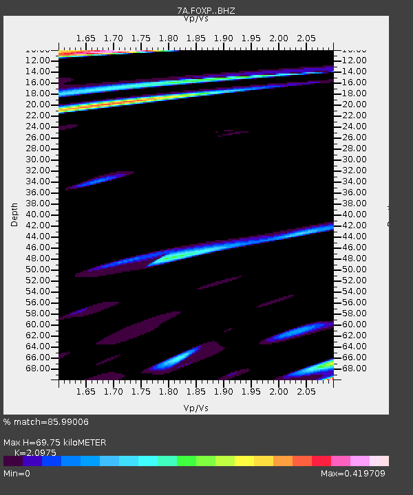
| Estimated Moho Depth: |
69.75 km |
| Estimated Crust Vp/Vs: |
2.10 |
| Assumed Crust Vp: |
6.159 km/s |
| Estimated Crust Vs: |
2.936 km/s |
| Estimated Crust Poisson's Ratio: |
0.35 |
|
| Radial Match: |
85.99006 % |
| Radial Bump: |
274 |
| Transverse Match: |
61.601654 % |
| Transverse Bump: |
400 |
| SOD ConfigId: |
7422571 |
| Insert Time: |
2019-04-22 21:32:03.069 +0000 |
| GWidth: |
2.5 |
| Max Bumps: |
400 |
| Tol: |
0.001 |
|

Signal To Noise
| Channel | StoN | STA | LTA |
| 7A:FOXP: :BHZ:20160621T16:32:40.130011Z | 3.2987773 | 3.3341695E-7 | 1.01072885E-7 |
| 7A:FOXP: :BHN:20160621T16:32:40.130011Z | 2.3810005 | 2.3056064E-7 | 9.683352E-8 |
| 7A:FOXP: :BHE:20160621T16:32:40.130011Z | 2.995151 | 1.9612338E-7 | 6.548029E-8 |
| Arrivals |
| Ps | 13 SECOND |
| PpPs | 33 SECOND |
| PsPs/PpSs | 46 SECOND |


