You are here: Home > Network List > BE - Belgian Seismic Network Stations List
> Station RCHB Rochefort, Belgium > Earthquake Result Viewer
RCHB Rochefort, Belgium - Earthquake Result Viewer
| Earthquake location: |
Northern Mid-Atlantic Ridge |
| Earthquake latitude/longitude: |
22.7/-45.1 |
| Earthquake time(UTC): |
2016/06/21 (173) 16:26:34 GMT |
| Earthquake Depth: |
10 km |
| Earthquake Magnitude: |
6.1 MWB |
| Earthquake Catalog/Contributor: |
NEIC PDE/NEIC COMCAT |
|
| Network: |
BE Belgian Seismic Network |
| Station: |
RCHB Rochefort, Belgium |
| Lat/Lon: |
50.16 N/5.23 E |
| Elevation: |
191 m |
|
| Distance: |
47.8 deg |
| Az: |
42.004 deg |
| Baz: |
253.939 deg |
| Ray Param: |
0.06979153 |
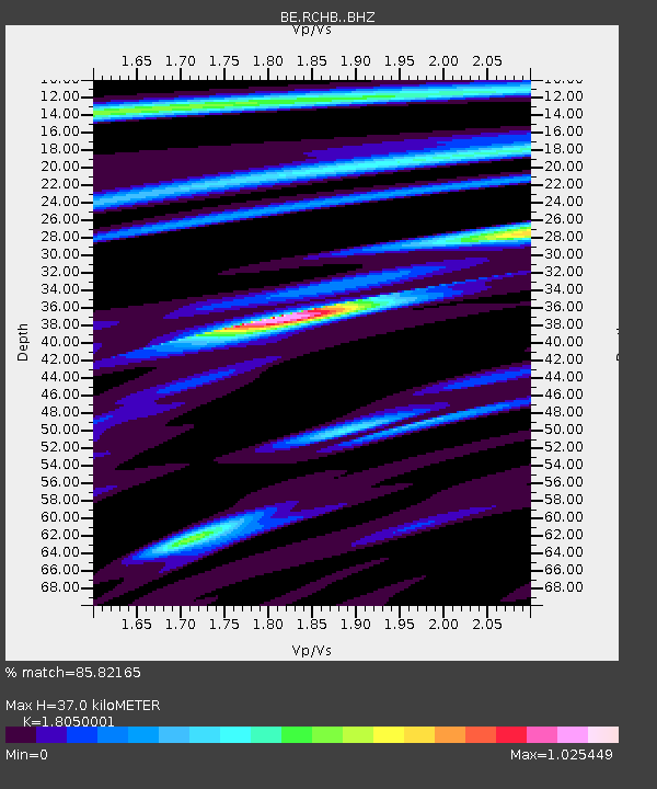
| Estimated Moho Depth: |
37.0 km |
| Estimated Crust Vp/Vs: |
1.81 |
| Assumed Crust Vp: |
6.276 km/s |
| Estimated Crust Vs: |
3.477 km/s |
| Estimated Crust Poisson's Ratio: |
0.28 |
|
| Radial Match: |
85.82165 % |
| Radial Bump: |
366 |
| Transverse Match: |
66.80043 % |
| Transverse Bump: |
400 |
| SOD ConfigId: |
7422571 |
| Insert Time: |
2019-04-22 21:33:50.235 +0000 |
| GWidth: |
2.5 |
| Max Bumps: |
400 |
| Tol: |
0.001 |
|

Signal To Noise
| Channel | StoN | STA | LTA |
| BE:RCHB: :BHZ:20160621T16:34:40.618994Z | 5.910372 | 7.6333487E-7 | 1.2915174E-7 |
| BE:RCHB: :BHN:20160621T16:34:40.618994Z | 0.5898709 | 9.609191E-8 | 1.6290328E-7 |
| BE:RCHB: :BHE:20160621T16:34:40.618994Z | 6.7222095 | 4.1997902E-7 | 6.247634E-8 |
| Arrivals |
| Ps | 5.0 SECOND |
| PpPs | 16 SECOND |
| PsPs/PpSs | 21 SECOND |


