You are here: Home > Network List > CN - Canadian National Seismograph Network Stations List
> Station KGNO KINGSTON, ON > Earthquake Result Viewer
KGNO KINGSTON, ON - Earthquake Result Viewer
| Earthquake location: |
Northern Mid-Atlantic Ridge |
| Earthquake latitude/longitude: |
22.7/-45.1 |
| Earthquake time(UTC): |
2016/06/21 (173) 16:26:34 GMT |
| Earthquake Depth: |
10 km |
| Earthquake Magnitude: |
6.1 MWB |
| Earthquake Catalog/Contributor: |
NEIC PDE/NEIC COMCAT |
|
| Network: |
CN Canadian National Seismograph Network |
| Station: |
KGNO KINGSTON, ON |
| Lat/Lon: |
44.23 N/76.49 W |
| Elevation: |
89 m |
|
| Distance: |
33.6 deg |
| Az: |
317.402 deg |
| Baz: |
119.58 deg |
| Ray Param: |
0.078152835 |
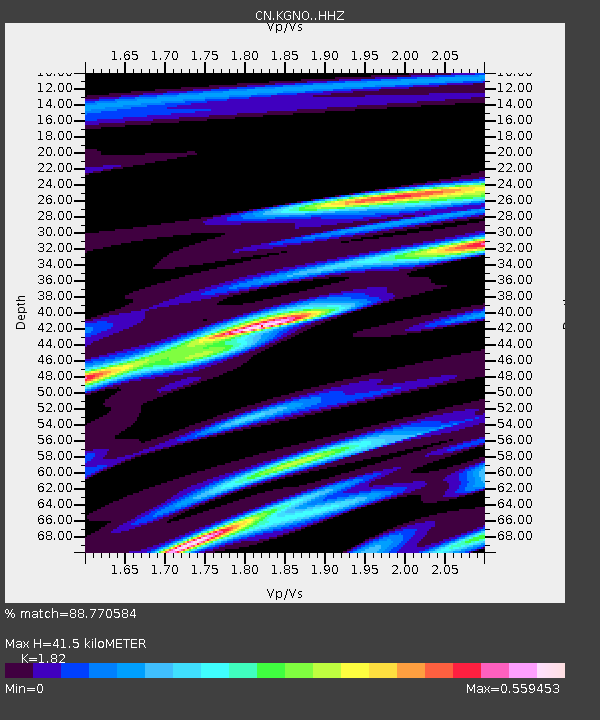
| Estimated Moho Depth: |
41.5 km |
| Estimated Crust Vp/Vs: |
1.82 |
| Assumed Crust Vp: |
6.577 km/s |
| Estimated Crust Vs: |
3.614 km/s |
| Estimated Crust Poisson's Ratio: |
0.28 |
|
| Radial Match: |
88.770584 % |
| Radial Bump: |
228 |
| Transverse Match: |
60.44529 % |
| Transverse Bump: |
400 |
| SOD ConfigId: |
7422571 |
| Insert Time: |
2019-04-22 21:35:22.217 +0000 |
| GWidth: |
2.5 |
| Max Bumps: |
400 |
| Tol: |
0.001 |
|

Signal To Noise
| Channel | StoN | STA | LTA |
| CN:KGNO: :HHZ:20160621T16:32:43.620001Z | 3.8038375 | 4.910154E-7 | 1.2908421E-7 |
| CN:KGNO: :HHN:20160621T16:32:43.620001Z | 1.5399814 | 1.1215817E-7 | 7.2830865E-8 |
| CN:KGNO: :HHE:20160621T16:32:43.620001Z | 2.7552662 | 2.673314E-7 | 9.702561E-8 |
| Arrivals |
| Ps | 5.6 SECOND |
| PpPs | 16 SECOND |
| PsPs/PpSs | 22 SECOND |


