You are here: Home > Network List > CN - Canadian National Seismograph Network Stations List
> Station SADO Sadowa, ON, CA > Earthquake Result Viewer
SADO Sadowa, ON, CA - Earthquake Result Viewer

| Earthquake location: |
Northern Mid-Atlantic Ridge |
| Earthquake latitude/longitude: |
22.7/-45.1 |
| Earthquake time(UTC): |
2016/06/21 (173) 16:26:34 GMT |
| Earthquake Depth: |
10 km |
| Earthquake Magnitude: |
6.1 MWB |
| Earthquake Catalog/Contributor: |
NEIC PDE/NEIC COMCAT |
|
| Network: |
CN Canadian National Seismograph Network |
| Station: |
SADO Sadowa, ON, CA |
| Lat/Lon: |
44.77 N/79.14 W |
| Elevation: |
228 m |
|
| Distance: |
35.5 deg |
| Az: |
316.656 deg |
| Baz: |
117.116 deg |
| Ray Param: |
0.07719998 |
| Estimated Moho Depth: |
36.75 km |
| Estimated Crust Vp/Vs: |
1.83 |
| Assumed Crust Vp: |
6.577 km/s |
| Estimated Crust Vs: |
3.599 km/s |
| Estimated Crust Poisson's Ratio: |
0.29 |
|
| Radial Match: |
89.01849 % |
| Radial Bump: |
357 |
| Transverse Match: |
61.68356 % |
| Transverse Bump: |
400 |
| SOD ConfigId: |
7422571 |
| Insert Time: |
2019-04-22 21:35:39.907 +0000 |
| GWidth: |
2.5 |
| Max Bumps: |
400 |
| Tol: |
0.001 |
|
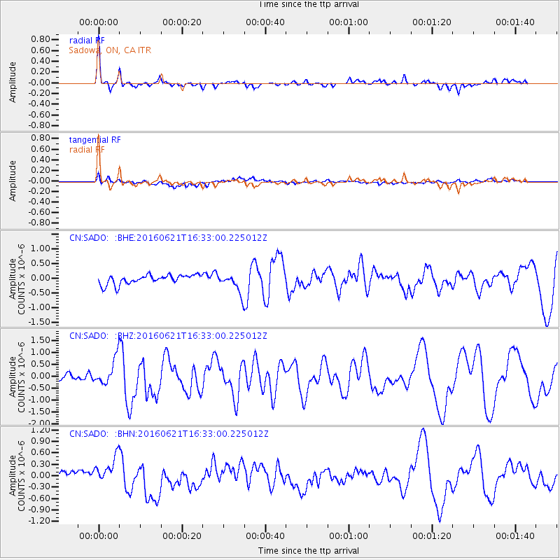
Signal To Noise
| Channel | StoN | STA | LTA |
| CN:SADO: :BHZ:20160621T16:33:00.225012Z | 4.592604 | 5.9023125E-7 | 1.2851777E-7 |
| CN:SADO: :BHN:20160621T16:33:00.225012Z | 2.981454 | 4.001801E-7 | 1.3422314E-7 |
| CN:SADO: :BHE:20160621T16:33:00.225012Z | 2.2060559 | 3.5473866E-7 | 1.6080222E-7 |
| Arrivals |
| Ps | 5.0 SECOND |
| PpPs | 15 SECOND |
| PsPs/PpSs | 20 SECOND |


