You are here: Home > Network List > CN - Canadian National Seismograph Network Stations List
> Station ULM LAC DU BONNET, MB > Earthquake Result Viewer
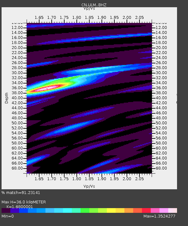
ULM LAC DU BONNET, MB - Earthquake Result Viewer
| Earthquake location: |
Northern Mid-Atlantic Ridge |
| Earthquake latitude/longitude: |
22.7/-45.1 |
| Earthquake time(UTC): |
2016/06/21 (173) 16:26:34 GMT |
| Earthquake Depth: |
10 km |
| Earthquake Magnitude: |
6.1 MWB |
| Earthquake Catalog/Contributor: |
NEIC PDE/NEIC COMCAT |
|
| Network: |
CN Canadian National Seismograph Network |
| Station: |
ULM LAC DU BONNET, MB |
| Lat/Lon: |
50.25 N/95.88 W |
| Elevation: |
251 m |
|
| Distance: |
48.0 deg |
| Az: |
318.028 deg |
| Baz: |
105.789 deg |
| Ray Param: |
0.06962874 |
| Estimated Moho Depth: |
36.0 km |
| Estimated Crust Vp/Vs: |
1.68 |
| Assumed Crust Vp: |
6.459 km/s |
| Estimated Crust Vs: |
3.845 km/s |
| Estimated Crust Poisson's Ratio: |
0.23 |
|
| Radial Match: |
91.23141 % |
| Radial Bump: |
317 |
| Transverse Match: |
67.56606 % |
| Transverse Bump: |
400 |
| SOD ConfigId: |
7422571 |
| Insert Time: |
2019-04-22 21:35:44.676 +0000 |
| GWidth: |
2.5 |
| Max Bumps: |
400 |
| Tol: |
0.001 |
|

Signal To Noise
| Channel | StoN | STA | LTA |
| CN:ULM: :BHZ:20160621T16:34:42.574988Z | 19.04138 | 8.107689E-7 | 4.2579313E-8 |
| CN:ULM: :BHN:20160621T16:34:42.574988Z | 1.9435129 | 9.8664444E-8 | 5.0766033E-8 |
| CN:ULM: :BHE:20160621T16:34:42.574988Z | 7.449481 | 4.3463456E-7 | 5.8344273E-8 |
| Arrivals |
| Ps | 4.0 SECOND |
| PpPs | 14 SECOND |
| PsPs/PpSs | 18 SECOND |


