You are here: Home > Network List > GB - Great Britain Seismograph Network Stations List
> Station DYA YADSWORTHY, ENGLAND > Earthquake Result Viewer
DYA YADSWORTHY, ENGLAND - Earthquake Result Viewer
| Earthquake location: |
Northern Mid-Atlantic Ridge |
| Earthquake latitude/longitude: |
22.7/-45.1 |
| Earthquake time(UTC): |
2016/06/21 (173) 16:26:34 GMT |
| Earthquake Depth: |
10 km |
| Earthquake Magnitude: |
6.1 MWB |
| Earthquake Catalog/Contributor: |
NEIC PDE/NEIC COMCAT |
|
| Network: |
GB Great Britain Seismograph Network |
| Station: |
DYA YADSWORTHY, ENGLAND |
| Lat/Lon: |
50.44 N/3.93 W |
| Elevation: |
292 m |
|
| Distance: |
42.4 deg |
| Az: |
38.698 deg |
| Baz: |
244.568 deg |
| Ray Param: |
0.07322117 |
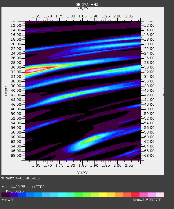
| Estimated Moho Depth: |
30.75 km |
| Estimated Crust Vp/Vs: |
1.65 |
| Assumed Crust Vp: |
6.182 km/s |
| Estimated Crust Vs: |
3.741 km/s |
| Estimated Crust Poisson's Ratio: |
0.21 |
|
| Radial Match: |
85.486916 % |
| Radial Bump: |
308 |
| Transverse Match: |
67.2549 % |
| Transverse Bump: |
400 |
| SOD ConfigId: |
7422571 |
| Insert Time: |
2019-04-22 21:36:23.703 +0000 |
| GWidth: |
2.5 |
| Max Bumps: |
400 |
| Tol: |
0.001 |
|

Signal To Noise
| Channel | StoN | STA | LTA |
| GB:DYA: :HHZ:20160621T16:33:57.790015Z | 4.2249036 | 9.650894E-7 | 2.2842872E-7 |
| GB:DYA: :HHN:20160621T16:33:57.790015Z | 1.0899528 | 2.6160816E-7 | 2.4001787E-7 |
| GB:DYA: :HHE:20160621T16:33:57.790015Z | 1.7904959 | 5.2806723E-7 | 2.949279E-7 |
| Arrivals |
| Ps | 3.5 SECOND |
| PpPs | 12 SECOND |
| PsPs/PpSs | 16 SECOND |


