You are here: Home > Network List > KN - Kyrgyz Seismic Telemetry Network Stations List
> Station TKM2 - > Earthquake Result Viewer
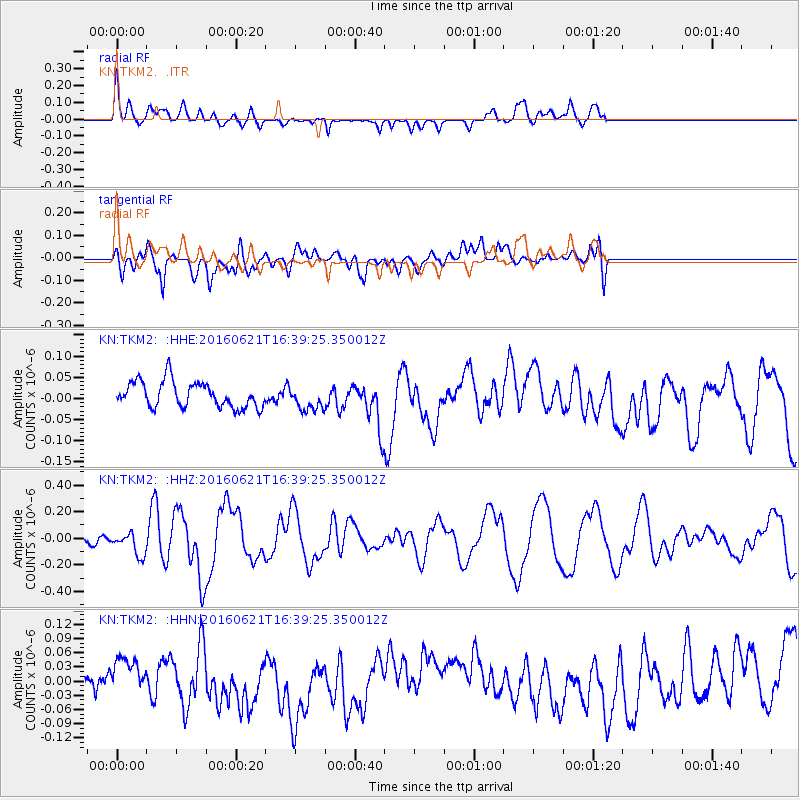
TKM2 - - Earthquake Result Viewer
*The percent match for this event was below the threshold and hence no stack was calculated.
| Earthquake location: |
Northern Mid-Atlantic Ridge |
| Earthquake latitude/longitude: |
22.7/-45.1 |
| Earthquake time(UTC): |
2016/06/21 (173) 16:26:34 GMT |
| Earthquake Depth: |
10 km |
| Earthquake Magnitude: |
6.1 MWB |
| Earthquake Catalog/Contributor: |
NEIC PDE/NEIC COMCAT |
|
| Network: |
KN Kyrgyz Seismic Telemetry Network |
| Station: |
TKM2 - |
| Lat/Lon: |
42.92 N/75.60 E |
| Elevation: |
2020 m |
|
| Distance: |
95.0 deg |
| Az: |
39.333 deg |
| Baz: |
307.153 deg |
| Ray Param: |
$rayparam |
*The percent match for this event was below the threshold and hence was not used in the summary stack. |
|
| Radial Match: |
69.50568 % |
| Radial Bump: |
400 |
| Transverse Match: |
68.31743 % |
| Transverse Bump: |
400 |
| SOD ConfigId: |
7422571 |
| Insert Time: |
2019-04-22 21:37:17.665 +0000 |
| GWidth: |
2.5 |
| Max Bumps: |
400 |
| Tol: |
0.001 |
|
Signal To Noise
| Channel | StoN | STA | LTA |
| KN:TKM2: :HHZ:20160621T16:39:25.350012Z | 2.983625 | 8.603298E-8 | 2.8835052E-8 |
| KN:TKM2: :HHN:20160621T16:39:25.350012Z | 1.123313 | 2.9389161E-8 | 2.6162933E-8 |
| KN:TKM2: :HHE:20160621T16:39:25.350012Z | 0.91545844 | 2.795239E-8 | 3.0533762E-8 |
| Arrivals |
| Ps | |
| PpPs | |
| PsPs/PpSs | |


