You are here: Home > Network List > N4 - Central and EAstern US Network Stations List
> Station E63A Oxbow, ME, USA > Earthquake Result Viewer
E63A Oxbow, ME, USA - Earthquake Result Viewer
| Earthquake location: |
Northern Mid-Atlantic Ridge |
| Earthquake latitude/longitude: |
22.7/-45.1 |
| Earthquake time(UTC): |
2016/06/21 (173) 16:26:34 GMT |
| Earthquake Depth: |
10 km |
| Earthquake Magnitude: |
6.1 MWB |
| Earthquake Catalog/Contributor: |
NEIC PDE/NEIC COMCAT |
|
| Network: |
N4 Central and EAstern US Network |
| Station: |
E63A Oxbow, ME, USA |
| Lat/Lon: |
46.42 N/68.46 W |
| Elevation: |
238 m |
|
| Distance: |
30.3 deg |
| Az: |
327.114 deg |
| Baz: |
133.529 deg |
| Ray Param: |
0.07936802 |
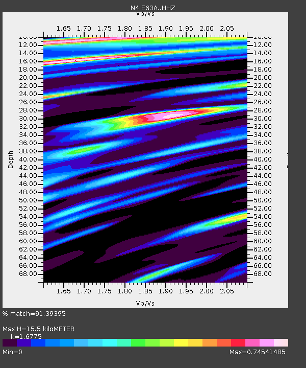
| Estimated Moho Depth: |
15.5 km |
| Estimated Crust Vp/Vs: |
1.68 |
| Assumed Crust Vp: |
6.419 km/s |
| Estimated Crust Vs: |
3.827 km/s |
| Estimated Crust Poisson's Ratio: |
0.22 |
|
| Radial Match: |
91.39395 % |
| Radial Bump: |
400 |
| Transverse Match: |
73.24204 % |
| Transverse Bump: |
400 |
| SOD ConfigId: |
7422571 |
| Insert Time: |
2019-04-22 21:38:16.426 +0000 |
| GWidth: |
2.5 |
| Max Bumps: |
400 |
| Tol: |
0.001 |
|

Signal To Noise
| Channel | StoN | STA | LTA |
| N4:E63A: :HHZ:20160621T16:32:15.120001Z | 3.8164449 | 7.7631677E-7 | 2.0341359E-7 |
| N4:E63A: :HHN:20160621T16:32:15.120001Z | 2.314922 | 2.7189904E-7 | 1.17454945E-7 |
| N4:E63A: :HHE:20160621T16:32:15.120001Z | 3.688899 | 4.619533E-7 | 1.2522796E-7 |
| Arrivals |
| Ps | 1.8 SECOND |
| PpPs | 5.9 SECOND |
| PsPs/PpSs | 7.7 SECOND |


