You are here: Home > Network List > WY - Yellowstone Wyoming Seismic Network Stations List
> Station YHH Holmes Hill, YNP, WY, USA > Earthquake Result Viewer
YHH Holmes Hill, YNP, WY, USA - Earthquake Result Viewer
*The percent match for this event was below the threshold and hence no stack was calculated.
| Earthquake location: |
Kuril Islands |
| Earthquake latitude/longitude: |
49.4/155.6 |
| Earthquake time(UTC): |
2015/09/05 (248) 13:16:10 GMT |
| Earthquake Depth: |
47 km |
| Earthquake Magnitude: |
5.9 MWB |
| Earthquake Catalog/Contributor: |
NEIC PDE/NEIC COMCAT |
|
| Network: |
WY Yellowstone Wyoming Seismic Network |
| Station: |
YHH Holmes Hill, YNP, WY, USA |
| Lat/Lon: |
44.79 N/110.85 W |
| Elevation: |
2717 m |
|
| Distance: |
59.8 deg |
| Az: |
55.302 deg |
| Baz: |
310.975 deg |
| Ray Param: |
$rayparam |
*The percent match for this event was below the threshold and hence was not used in the summary stack. |
|
| Radial Match: |
69.765724 % |
| Radial Bump: |
400 |
| Transverse Match: |
66.058495 % |
| Transverse Bump: |
400 |
| SOD ConfigId: |
1156111 |
| Insert Time: |
2015-09-19 13:44:44.701 +0000 |
| GWidth: |
2.5 |
| Max Bumps: |
400 |
| Tol: |
0.001 |
|
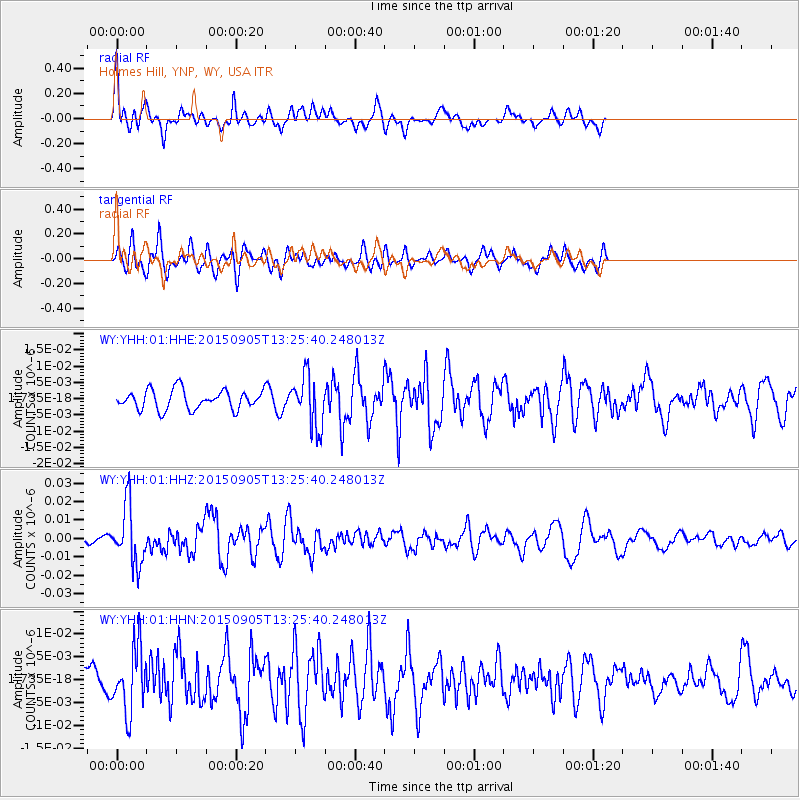
Signal To Noise
| Channel | StoN | STA | LTA |
| WY:YHH:01:HHZ:20150905T13:25:40.248013Z | 7.0311255 | 1.6030834E-8 | 2.279981E-9 |
| WY:YHH:01:HHN:20150905T13:25:40.248013Z | 2.356053 | 7.056475E-9 | 2.9950409E-9 |
| WY:YHH:01:HHE:20150905T13:25:40.248013Z | 2.6568673 | 7.837437E-9 | 2.9498792E-9 |
| Arrivals |
| Ps | |
| PpPs | |
| PsPs/PpSs | |


