You are here: Home > Network List > N4 - Central and EAstern US Network Stations List
> Station P51A Williamsport, OH, USA > Earthquake Result Viewer
P51A Williamsport, OH, USA - Earthquake Result Viewer
| Earthquake location: |
Northern Mid-Atlantic Ridge |
| Earthquake latitude/longitude: |
22.7/-45.1 |
| Earthquake time(UTC): |
2016/06/21 (173) 16:26:34 GMT |
| Earthquake Depth: |
10 km |
| Earthquake Magnitude: |
6.1 MWB |
| Earthquake Catalog/Contributor: |
NEIC PDE/NEIC COMCAT |
|
| Network: |
N4 Central and EAstern US Network |
| Station: |
P51A Williamsport, OH, USA |
| Lat/Lon: |
39.48 N/83.06 W |
| Elevation: |
211 m |
|
| Distance: |
36.2 deg |
| Az: |
306.431 deg |
| Baz: |
106.199 deg |
| Ray Param: |
0.07678549 |
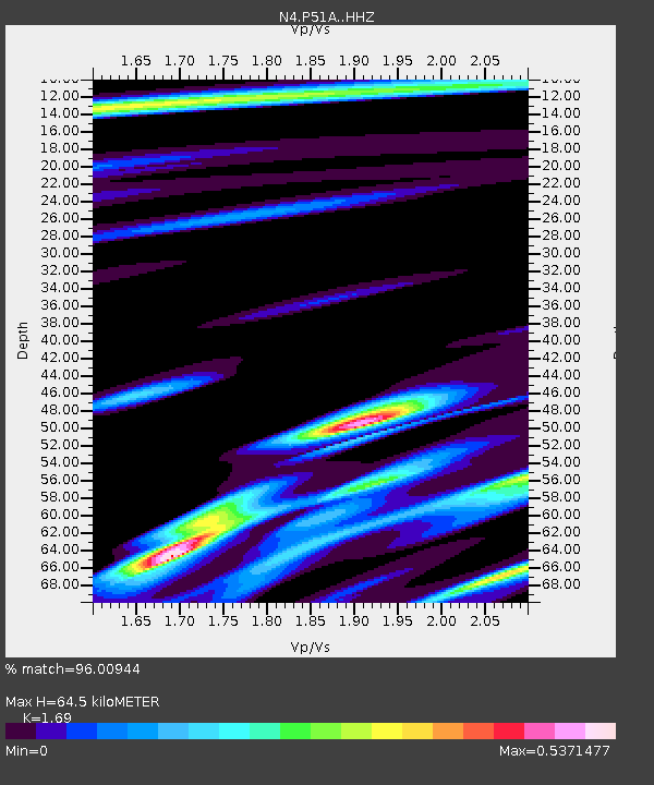
| Estimated Moho Depth: |
64.5 km |
| Estimated Crust Vp/Vs: |
1.69 |
| Assumed Crust Vp: |
6.232 km/s |
| Estimated Crust Vs: |
3.687 km/s |
| Estimated Crust Poisson's Ratio: |
0.23 |
|
| Radial Match: |
96.00944 % |
| Radial Bump: |
159 |
| Transverse Match: |
65.9642 % |
| Transverse Bump: |
400 |
| SOD ConfigId: |
7422571 |
| Insert Time: |
2019-04-22 21:38:53.486 +0000 |
| GWidth: |
2.5 |
| Max Bumps: |
400 |
| Tol: |
0.001 |
|

Signal To Noise
| Channel | StoN | STA | LTA |
| N4:P51A: :HHZ:20160621T16:33:06.750006Z | 6.445881 | 5.8678563E-7 | 9.1032646E-8 |
| N4:P51A: :HHN:20160621T16:33:06.750006Z | 1.1269374 | 1.1487904E-7 | 1.0193915E-7 |
| N4:P51A: :HHE:20160621T16:33:06.750006Z | 4.0679755 | 4.0841698E-7 | 1.003981E-7 |
| Arrivals |
| Ps | 7.7 SECOND |
| PpPs | 26 SECOND |
| PsPs/PpSs | 34 SECOND |


