You are here: Home > Network List > N4 - Central and EAstern US Network Stations List
> Station T60A Surry, VA, USA > Earthquake Result Viewer
T60A Surry, VA, USA - Earthquake Result Viewer
| Earthquake location: |
Northern Mid-Atlantic Ridge |
| Earthquake latitude/longitude: |
22.7/-45.1 |
| Earthquake time(UTC): |
2016/06/21 (173) 16:26:34 GMT |
| Earthquake Depth: |
10 km |
| Earthquake Magnitude: |
6.1 MWB |
| Earthquake Catalog/Contributor: |
NEIC PDE/NEIC COMCAT |
|
| Network: |
N4 Central and EAstern US Network |
| Station: |
T60A Surry, VA, USA |
| Lat/Lon: |
37.14 N/76.73 W |
| Elevation: |
11 m |
|
| Distance: |
30.8 deg |
| Az: |
305.126 deg |
| Baz: |
109.018 deg |
| Ray Param: |
0.079237886 |
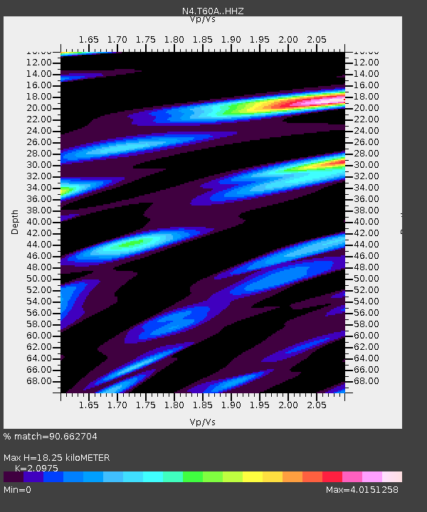
| Estimated Moho Depth: |
18.25 km |
| Estimated Crust Vp/Vs: |
2.10 |
| Assumed Crust Vp: |
6.565 km/s |
| Estimated Crust Vs: |
3.13 km/s |
| Estimated Crust Poisson's Ratio: |
0.35 |
|
| Radial Match: |
90.662704 % |
| Radial Bump: |
400 |
| Transverse Match: |
49.888283 % |
| Transverse Bump: |
400 |
| SOD ConfigId: |
7422571 |
| Insert Time: |
2019-04-22 21:39:10.449 +0000 |
| GWidth: |
2.5 |
| Max Bumps: |
400 |
| Tol: |
0.001 |
|

Signal To Noise
| Channel | StoN | STA | LTA |
| N4:T60A: :HHZ:20160621T16:32:19.459998Z | 3.669932 | 7.1933977E-7 | 1.9600903E-7 |
| N4:T60A: :HHN:20160621T16:32:19.459998Z | 1.0618182 | 5.230018E-7 | 4.92553E-7 |
| N4:T60A: :HHE:20160621T16:32:19.459998Z | 0.9500222 | 5.6094905E-7 | 5.9045885E-7 |
| Arrivals |
| Ps | 3.3 SECOND |
| PpPs | 8.0 SECOND |
| PsPs/PpSs | 11 SECOND |


