You are here: Home > Network List > OK - Oklahoma Seismic Network Stations List
> Station CCOK Cow Creek > Earthquake Result Viewer
CCOK Cow Creek - Earthquake Result Viewer
| Earthquake location: |
Northern Mid-Atlantic Ridge |
| Earthquake latitude/longitude: |
22.7/-45.1 |
| Earthquake time(UTC): |
2016/06/21 (173) 16:26:34 GMT |
| Earthquake Depth: |
10 km |
| Earthquake Magnitude: |
6.1 MWB |
| Earthquake Catalog/Contributor: |
NEIC PDE/NEIC COMCAT |
|
| Network: |
OK Oklahoma Seismic Network |
| Station: |
CCOK Cow Creek |
| Lat/Lon: |
35.36 N/97.66 W |
| Elevation: |
378 m |
|
| Distance: |
47.2 deg |
| Az: |
297.772 deg |
| Baz: |
90.832 deg |
| Ray Param: |
0.07018162 |
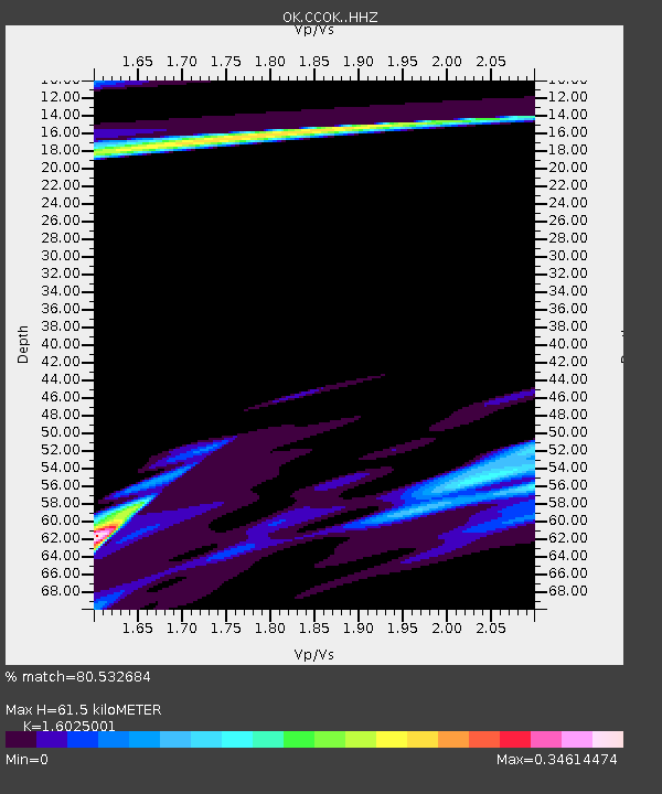
| Estimated Moho Depth: |
61.5 km |
| Estimated Crust Vp/Vs: |
1.60 |
| Assumed Crust Vp: |
6.426 km/s |
| Estimated Crust Vs: |
4.01 km/s |
| Estimated Crust Poisson's Ratio: |
0.18 |
|
| Radial Match: |
80.532684 % |
| Radial Bump: |
400 |
| Transverse Match: |
39.708935 % |
| Transverse Bump: |
400 |
| SOD ConfigId: |
7422571 |
| Insert Time: |
2019-04-22 21:40:06.838 +0000 |
| GWidth: |
2.5 |
| Max Bumps: |
400 |
| Tol: |
0.001 |
|

Signal To Noise
| Channel | StoN | STA | LTA |
| OK:CCOK: :HHZ:20160621T16:34:35.859015Z | 4.5613875 | 8.407494E-7 | 1.8431878E-7 |
| OK:CCOK: :HHN:20160621T16:34:35.859015Z | 1.5464561 | 1.6559957E-6 | 1.0708326E-6 |
| OK:CCOK: :HHE:20160621T16:34:35.859015Z | 1.2244097 | 5.401749E-7 | 4.4117164E-7 |
| Arrivals |
| Ps | 6.2 SECOND |
| PpPs | 23 SECOND |
| PsPs/PpSs | 29 SECOND |


