You are here: Home > Network List > OX - North-East Italy Seismic Network Stations List
> Station CGRP Cima Grappa > Earthquake Result Viewer
CGRP Cima Grappa - Earthquake Result Viewer
| Earthquake location: |
Northern Mid-Atlantic Ridge |
| Earthquake latitude/longitude: |
22.7/-45.1 |
| Earthquake time(UTC): |
2016/06/21 (173) 16:26:34 GMT |
| Earthquake Depth: |
10 km |
| Earthquake Magnitude: |
6.1 MWB |
| Earthquake Catalog/Contributor: |
NEIC PDE/NEIC COMCAT |
|
| Network: |
OX North-East Italy Seismic Network |
| Station: |
CGRP Cima Grappa |
| Lat/Lon: |
45.88 N/11.80 E |
| Elevation: |
1757 m |
|
| Distance: |
51.2 deg |
| Az: |
48.665 deg |
| Baz: |
263.151 deg |
| Ray Param: |
0.06754212 |
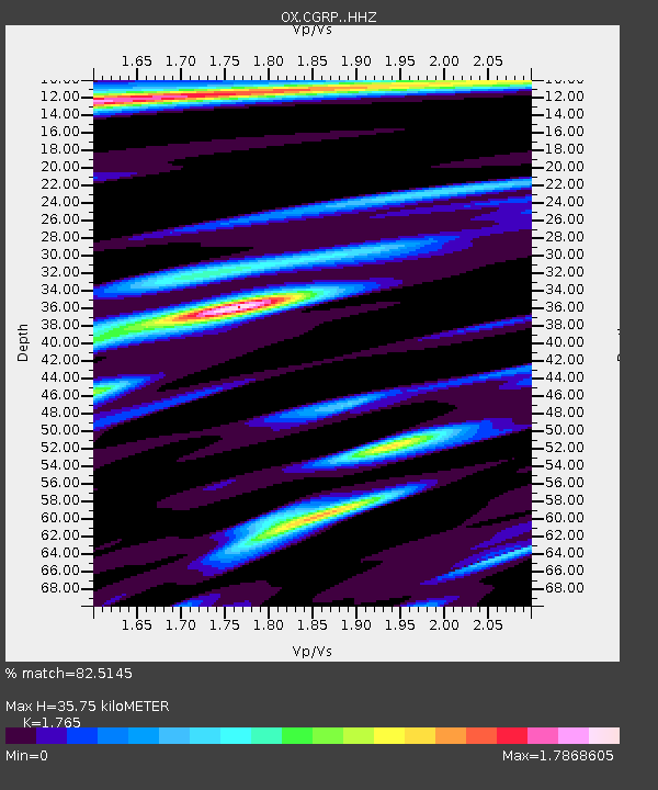
| Estimated Moho Depth: |
35.75 km |
| Estimated Crust Vp/Vs: |
1.76 |
| Assumed Crust Vp: |
6.155 km/s |
| Estimated Crust Vs: |
3.487 km/s |
| Estimated Crust Poisson's Ratio: |
0.26 |
|
| Radial Match: |
82.5145 % |
| Radial Bump: |
400 |
| Transverse Match: |
74.21357 % |
| Transverse Bump: |
400 |
| SOD ConfigId: |
7422571 |
| Insert Time: |
2019-04-22 21:40:18.760 +0000 |
| GWidth: |
2.5 |
| Max Bumps: |
400 |
| Tol: |
0.001 |
|

Signal To Noise
| Channel | StoN | STA | LTA |
| OX:CGRP: :HHZ:20160621T16:35:07.147986Z | 11.289918 | 1.0344806E-6 | 9.1628706E-8 |
| OX:CGRP: :HHN:20160621T16:35:07.147986Z | 3.5431495 | 2.929184E-7 | 8.267176E-8 |
| OX:CGRP: :HHE:20160621T16:35:07.147986Z | 6.2493267 | 5.7882704E-7 | 9.262231E-8 |
| Arrivals |
| Ps | 4.7 SECOND |
| PpPs | 15 SECOND |
| PsPs/PpSs | 20 SECOND |


