You are here: Home > Network List > US - United States National Seismic Network Stations List
> Station WUAZ Wupatki, Arizona, USA > Earthquake Result Viewer
WUAZ Wupatki, Arizona, USA - Earthquake Result Viewer
| Earthquake location: |
Northern Chile |
| Earthquake latitude/longitude: |
-18.2/-69.4 |
| Earthquake time(UTC): |
2001/08/09 (221) 03:33:44 GMT |
| Earthquake Depth: |
113 km |
| Earthquake Magnitude: |
5.5 MB, 5.6 MW |
| Earthquake Catalog/Contributor: |
WHDF/NEIC |
|
| Network: |
US United States National Seismic Network |
| Station: |
WUAZ Wupatki, Arizona, USA |
| Lat/Lon: |
35.52 N/111.37 W |
| Elevation: |
1592 m |
|
| Distance: |
66.6 deg |
| Az: |
323.537 deg |
| Baz: |
136.16 deg |
| Ray Param: |
0.057225473 |
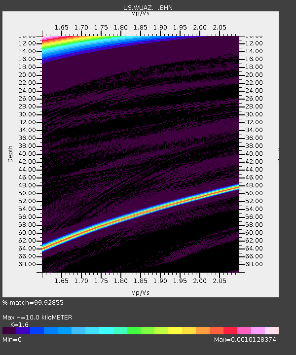
| Estimated Moho Depth: |
10.0 km |
| Estimated Crust Vp/Vs: |
1.60 |
| Assumed Crust Vp: |
6.207 km/s |
| Estimated Crust Vs: |
3.879 km/s |
| Estimated Crust Poisson's Ratio: |
0.18 |
|
| Radial Match: |
99.92855 % |
| Radial Bump: |
14 |
| Transverse Match: |
94.68932 % |
| Transverse Bump: |
186 |
| SOD ConfigId: |
110165 |
| Insert Time: |
2010-03-05 04:46:52.675 +0000 |
| GWidth: |
2.5 |
| Max Bumps: |
400 |
| Tol: |
0.001 |
|

Signal To Noise
| Channel | StoN | STA | LTA |
| US:WUAZ: :BHN:20010809T03:43:52.24001Z | 0.9110631 | 5.592982E-7 | 6.1389625E-7 |
| US:WUAZ: :BHE:20010809T03:43:52.24001Z | 0.90960604 | 6.850012E-7 | 7.530747E-7 |
| US:WUAZ: :BHZ:20010809T03:43:52.24001Z | 0.8988838 | 5.6029614E-7 | 6.233243E-7 |
| Arrivals |
| Ps | 1.0 SECOND |
| PpPs | 4.0 SECOND |
| PsPs/PpSs | 5.0 SECOND |


