You are here: Home > Network List > RV - Regional Alberta Seismic Observatory for Earthquake Studies Network Stations List
> Station BRLDA Berland Lookout Tower, AB > Earthquake Result Viewer
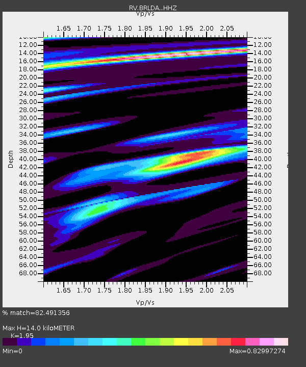
BRLDA Berland Lookout Tower, AB - Earthquake Result Viewer
| Earthquake location: |
Northern Mid-Atlantic Ridge |
| Earthquake latitude/longitude: |
22.7/-45.1 |
| Earthquake time(UTC): |
2016/06/21 (173) 16:26:34 GMT |
| Earthquake Depth: |
10 km |
| Earthquake Magnitude: |
6.1 MWB |
| Earthquake Catalog/Contributor: |
NEIC PDE/NEIC COMCAT |
|
| Network: |
RV Regional Alberta Seismic Observatory for Earthquake Studies Network |
| Station: |
BRLDA Berland Lookout Tower, AB |
| Lat/Lon: |
54.09 N/117.40 W |
| Elevation: |
1224 m |
|
| Distance: |
61.6 deg |
| Az: |
320.378 deg |
| Baz: |
90.107 deg |
| Ray Param: |
0.06075558 |
| Estimated Moho Depth: |
14.0 km |
| Estimated Crust Vp/Vs: |
1.95 |
| Assumed Crust Vp: |
6.426 km/s |
| Estimated Crust Vs: |
3.295 km/s |
| Estimated Crust Poisson's Ratio: |
0.32 |
|
| Radial Match: |
82.491356 % |
| Radial Bump: |
400 |
| Transverse Match: |
54.256523 % |
| Transverse Bump: |
400 |
| SOD ConfigId: |
7422571 |
| Insert Time: |
2019-04-22 21:41:10.747 +0000 |
| GWidth: |
2.5 |
| Max Bumps: |
400 |
| Tol: |
0.001 |
|

Signal To Noise
| Channel | StoN | STA | LTA |
| RV:BRLDA: :HHZ:20160621T16:36:20.980017Z | 6.857071 | 7.069191E-7 | 1.0309345E-7 |
| RV:BRLDA: :HHN:20160621T16:36:20.980017Z | 1.2633786 | 1.5914236E-7 | 1.2596568E-7 |
| RV:BRLDA: :HHE:20160621T16:36:20.980017Z | 2.1516824 | 3.040538E-7 | 1.413098E-7 |
| Arrivals |
| Ps | 2.2 SECOND |
| PpPs | 6.2 SECOND |
| PsPs/PpSs | 8.3 SECOND |


