You are here: Home > Network List > US - United States National Seismic Network Stations List
> Station WUAZ Wupatki, Arizona, USA > Earthquake Result Viewer
WUAZ Wupatki, Arizona, USA - Earthquake Result Viewer

| Earthquake location: |
Northern Chile |
| Earthquake latitude/longitude: |
-19.4/-69.3 |
| Earthquake time(UTC): |
2001/07/24 (205) 05:00:09 GMT |
| Earthquake Depth: |
33 km |
| Earthquake Magnitude: |
5.7 MB, 6.2 MS, 6.3 MW, 6.3 MW |
| Earthquake Catalog/Contributor: |
WHDF/NEIC |
|
| Network: |
US United States National Seismic Network |
| Station: |
WUAZ Wupatki, Arizona, USA |
| Lat/Lon: |
35.52 N/111.37 W |
| Elevation: |
1592 m |
|
| Distance: |
67.7 deg |
| Az: |
323.745 deg |
| Baz: |
136.837 deg |
| Ray Param: |
0.05674005 |
| Estimated Moho Depth: |
10.0 km |
| Estimated Crust Vp/Vs: |
1.60 |
| Assumed Crust Vp: |
6.207 km/s |
| Estimated Crust Vs: |
3.879 km/s |
| Estimated Crust Poisson's Ratio: |
0.18 |
|
| Radial Match: |
99.96695 % |
| Radial Bump: |
5 |
| Transverse Match: |
92.011604 % |
| Transverse Bump: |
137 |
| SOD ConfigId: |
110165 |
| Insert Time: |
2010-03-05 04:46:57.602 +0000 |
| GWidth: |
2.5 |
| Max Bumps: |
400 |
| Tol: |
0.001 |
|
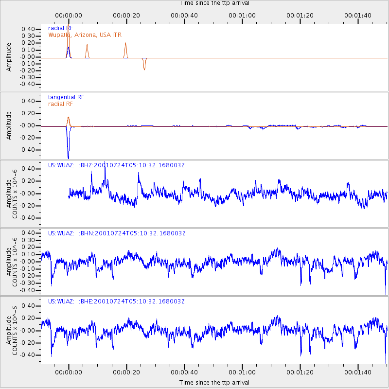
Signal To Noise
| Channel | StoN | STA | LTA |
| US:WUAZ: :BHN:20010724T05:10:32.168003Z | 0.65933186 | 6.490904E-8 | 9.8446684E-8 |
| US:WUAZ: :BHE:20010724T05:10:32.168003Z | 0.64614433 | 7.969186E-8 | 1.2333446E-7 |
| US:WUAZ: :BHZ:20010724T05:10:32.168003Z | 0.56975704 | 6.449701E-8 | 1.132009E-7 |
| Arrivals |
| Ps | 1.0 SECOND |
| PpPs | 4.0 SECOND |
| PsPs/PpSs | 5.0 SECOND |


