You are here: Home > Network List > TA - USArray Transportable Network (new EarthScope stations) Stations List
> Station C36M Paulatuk, NT, CAN > Earthquake Result Viewer
C36M Paulatuk, NT, CAN - Earthquake Result Viewer
| Earthquake location: |
Northern Mid-Atlantic Ridge |
| Earthquake latitude/longitude: |
22.7/-45.1 |
| Earthquake time(UTC): |
2016/06/21 (173) 16:26:34 GMT |
| Earthquake Depth: |
10 km |
| Earthquake Magnitude: |
6.1 MWB |
| Earthquake Catalog/Contributor: |
NEIC PDE/NEIC COMCAT |
|
| Network: |
TA USArray Transportable Network (new EarthScope stations) |
| Station: |
C36M Paulatuk, NT, CAN |
| Lat/Lon: |
69.35 N/124.07 W |
| Elevation: |
10 m |
|
| Distance: |
65.1 deg |
| Az: |
337.426 deg |
| Baz: |
91.883 deg |
| Ray Param: |
0.058494296 |
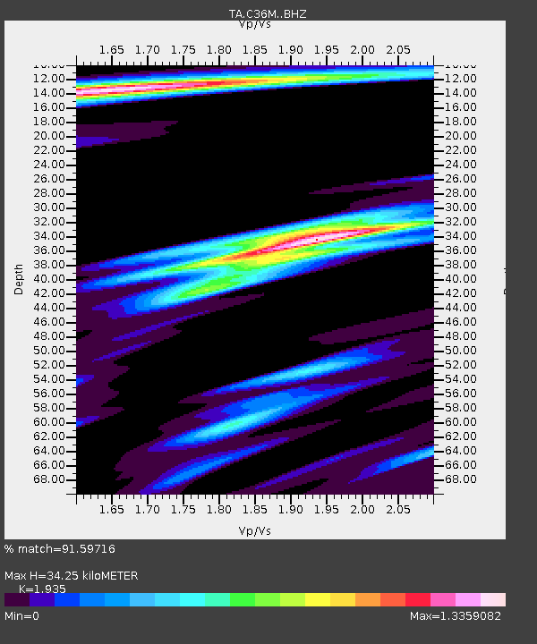
| Estimated Moho Depth: |
34.25 km |
| Estimated Crust Vp/Vs: |
1.93 |
| Assumed Crust Vp: |
6.459 km/s |
| Estimated Crust Vs: |
3.338 km/s |
| Estimated Crust Poisson's Ratio: |
0.32 |
|
| Radial Match: |
91.59716 % |
| Radial Bump: |
400 |
| Transverse Match: |
84.14741 % |
| Transverse Bump: |
400 |
| SOD ConfigId: |
7422571 |
| Insert Time: |
2019-04-22 21:41:34.321 +0000 |
| GWidth: |
2.5 |
| Max Bumps: |
400 |
| Tol: |
0.001 |
|

Signal To Noise
| Channel | StoN | STA | LTA |
| TA:C36M: :BHZ:20160621T16:36:43.973975Z | 6.090318 | 3.9974466E-7 | 6.563609E-8 |
| TA:C36M: :BHN:20160621T16:36:43.973975Z | 1.4031307 | 6.604409E-8 | 4.7069094E-8 |
| TA:C36M: :BHE:20160621T16:36:43.973975Z | 4.516198 | 2.0957347E-7 | 4.6404846E-8 |
| Arrivals |
| Ps | 5.2 SECOND |
| PpPs | 15 SECOND |
| PsPs/PpSs | 20 SECOND |


