You are here: Home > Network List > TA - USArray Transportable Network (new EarthScope stations) Stations List
> Station G05D Wamic, OR, USA > Earthquake Result Viewer
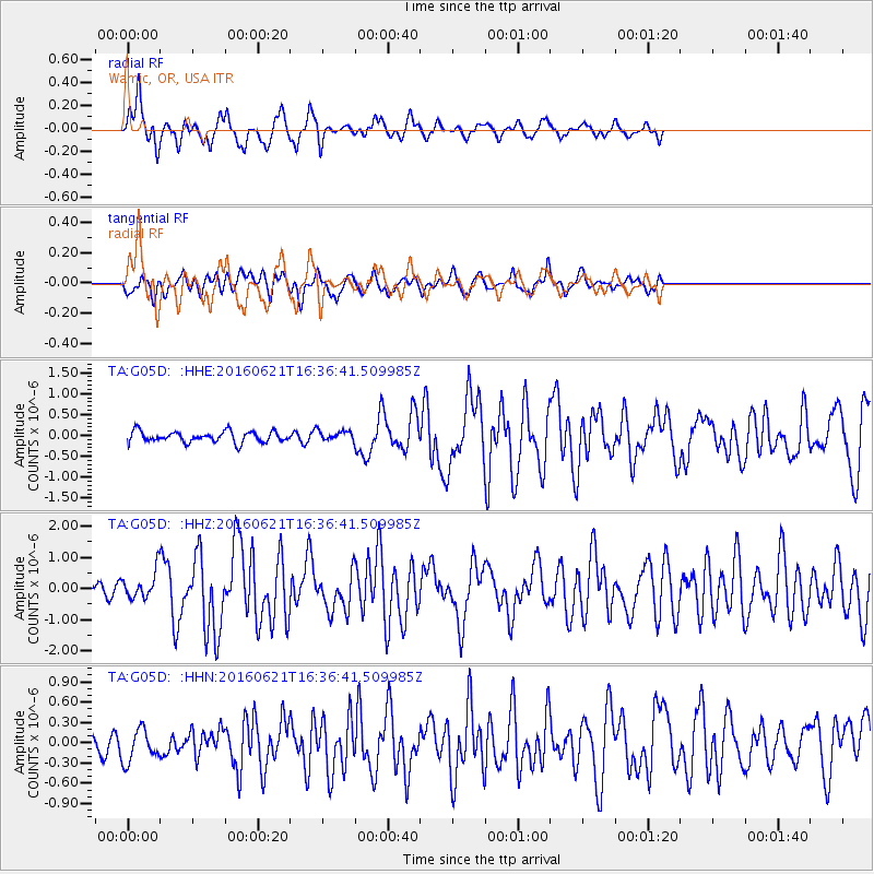
G05D Wamic, OR, USA - Earthquake Result Viewer
*The percent match for this event was below the threshold and hence no stack was calculated.
| Earthquake location: |
Northern Mid-Atlantic Ridge |
| Earthquake latitude/longitude: |
22.7/-45.1 |
| Earthquake time(UTC): |
2016/06/21 (173) 16:26:34 GMT |
| Earthquake Depth: |
10 km |
| Earthquake Magnitude: |
6.1 MWB |
| Earthquake Catalog/Contributor: |
NEIC PDE/NEIC COMCAT |
|
| Network: |
TA USArray Transportable Network (new EarthScope stations) |
| Station: |
G05D Wamic, OR, USA |
| Lat/Lon: |
45.24 N/121.32 W |
| Elevation: |
592 m |
|
| Distance: |
64.7 deg |
| Az: |
310.652 deg |
| Baz: |
82.724 deg |
| Ray Param: |
$rayparam |
*The percent match for this event was below the threshold and hence was not used in the summary stack. |
|
| Radial Match: |
82.3727 % |
| Radial Bump: |
381 |
| Transverse Match: |
66.76591 % |
| Transverse Bump: |
400 |
| SOD ConfigId: |
7422571 |
| Insert Time: |
2019-04-22 21:41:39.666 +0000 |
| GWidth: |
2.5 |
| Max Bumps: |
400 |
| Tol: |
0.001 |
|
Signal To Noise
| Channel | StoN | STA | LTA |
| TA:G05D: :HHZ:20160621T16:36:41.509985Z | 2.731245 | 4.226787E-7 | 1.5475679E-7 |
| TA:G05D: :HHN:20160621T16:36:41.509985Z | 1.6977974 | 2.6376586E-7 | 1.5535768E-7 |
| TA:G05D: :HHE:20160621T16:36:41.509985Z | 0.903483 | 1.2080108E-7 | 1.3370598E-7 |
| Arrivals |
| Ps | |
| PpPs | |
| PsPs/PpSs | |


