You are here: Home > Network List > TA - USArray Transportable Network (new EarthScope stations) Stations List
> Station I04A Tendick Farm, Oakridge, OR, USA > Earthquake Result Viewer
I04A Tendick Farm, Oakridge, OR, USA - Earthquake Result Viewer
| Earthquake location: |
Northern Mid-Atlantic Ridge |
| Earthquake latitude/longitude: |
22.7/-45.1 |
| Earthquake time(UTC): |
2016/06/21 (173) 16:26:34 GMT |
| Earthquake Depth: |
10 km |
| Earthquake Magnitude: |
6.1 MWB |
| Earthquake Catalog/Contributor: |
NEIC PDE/NEIC COMCAT |
|
| Network: |
TA USArray Transportable Network (new EarthScope stations) |
| Station: |
I04A Tendick Farm, Oakridge, OR, USA |
| Lat/Lon: |
43.79 N/122.41 W |
| Elevation: |
731 m |
|
| Distance: |
65.7 deg |
| Az: |
309.192 deg |
| Baz: |
81.347 deg |
| Ray Param: |
0.058098882 |
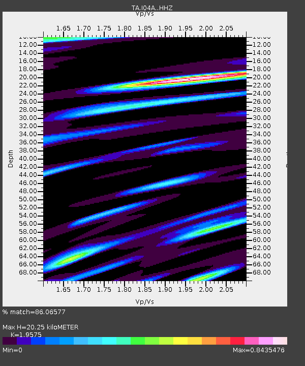
| Estimated Moho Depth: |
20.25 km |
| Estimated Crust Vp/Vs: |
1.96 |
| Assumed Crust Vp: |
6.522 km/s |
| Estimated Crust Vs: |
3.332 km/s |
| Estimated Crust Poisson's Ratio: |
0.32 |
|
| Radial Match: |
86.06577 % |
| Radial Bump: |
392 |
| Transverse Match: |
71.54044 % |
| Transverse Bump: |
400 |
| SOD ConfigId: |
7422571 |
| Insert Time: |
2019-04-22 21:41:48.196 +0000 |
| GWidth: |
2.5 |
| Max Bumps: |
400 |
| Tol: |
0.001 |
|

Signal To Noise
| Channel | StoN | STA | LTA |
| TA:I04A: :HHZ:20160621T16:36:47.829993Z | 5.3040886 | 4.0213317E-7 | 7.58157E-8 |
| TA:I04A: :HHN:20160621T16:36:47.829993Z | 1.5367864 | 8.8916E-8 | 5.78584E-8 |
| TA:I04A: :HHE:20160621T16:36:47.829993Z | 1.4678963 | 9.516526E-8 | 6.483105E-8 |
| Arrivals |
| Ps | 3.1 SECOND |
| PpPs | 8.8 SECOND |
| PsPs/PpSs | 12 SECOND |


