You are here: Home > Network List > TA - USArray Transportable Network (new EarthScope stations) Stations List
> Station I21K Tanana, AK, USA > Earthquake Result Viewer
I21K Tanana, AK, USA - Earthquake Result Viewer
| Earthquake location: |
Northern Mid-Atlantic Ridge |
| Earthquake latitude/longitude: |
22.7/-45.1 |
| Earthquake time(UTC): |
2016/06/21 (173) 16:26:34 GMT |
| Earthquake Depth: |
10 km |
| Earthquake Magnitude: |
6.1 MWB |
| Earthquake Catalog/Contributor: |
NEIC PDE/NEIC COMCAT |
|
| Network: |
TA USArray Transportable Network (new EarthScope stations) |
| Station: |
I21K Tanana, AK, USA |
| Lat/Lon: |
65.18 N/151.98 W |
| Elevation: |
248 m |
|
| Distance: |
76.5 deg |
| Az: |
335.447 deg |
| Baz: |
65.418 deg |
| Ray Param: |
0.050985314 |
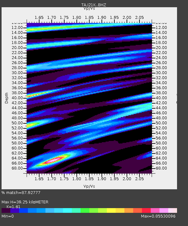
| Estimated Moho Depth: |
39.25 km |
| Estimated Crust Vp/Vs: |
1.61 |
| Assumed Crust Vp: |
6.566 km/s |
| Estimated Crust Vs: |
4.078 km/s |
| Estimated Crust Poisson's Ratio: |
0.19 |
|
| Radial Match: |
87.92777 % |
| Radial Bump: |
400 |
| Transverse Match: |
72.44391 % |
| Transverse Bump: |
400 |
| SOD ConfigId: |
7422571 |
| Insert Time: |
2019-04-22 21:41:48.308 +0000 |
| GWidth: |
2.5 |
| Max Bumps: |
400 |
| Tol: |
0.001 |
|

Signal To Noise
| Channel | StoN | STA | LTA |
| TA:I21K: :BHZ:20160621T16:37:52.850012Z | 5.6849008 | 3.6746846E-7 | 6.463938E-8 |
| TA:I21K: :BHN:20160621T16:37:52.850012Z | 1.3820602 | 8.9622475E-8 | 6.4847015E-8 |
| TA:I21K: :BHE:20160621T16:37:52.850012Z | 1.6501801 | 1.5116811E-7 | 9.1607035E-8 |
| Arrivals |
| Ps | 3.8 SECOND |
| PpPs | 15 SECOND |
| PsPs/PpSs | 19 SECOND |


