You are here: Home > Network List > TA - USArray Transportable Network (new EarthScope stations) Stations List
> Station J26L Joseph Creek, AK, USA > Earthquake Result Viewer
J26L Joseph Creek, AK, USA - Earthquake Result Viewer
| Earthquake location: |
Northern Mid-Atlantic Ridge |
| Earthquake latitude/longitude: |
22.7/-45.1 |
| Earthquake time(UTC): |
2016/06/21 (173) 16:26:34 GMT |
| Earthquake Depth: |
10 km |
| Earthquake Magnitude: |
6.1 MWB |
| Earthquake Catalog/Contributor: |
NEIC PDE/NEIC COMCAT |
|
| Network: |
TA USArray Transportable Network (new EarthScope stations) |
| Station: |
J26L Joseph Creek, AK, USA |
| Lat/Lon: |
64.50 N/143.56 W |
| Elevation: |
1144 m |
|
| Distance: |
73.3 deg |
| Az: |
333.453 deg |
| Baz: |
72.511 deg |
| Ray Param: |
0.05307018 |
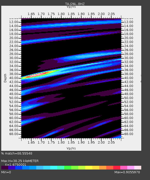
| Estimated Moho Depth: |
38.25 km |
| Estimated Crust Vp/Vs: |
1.68 |
| Assumed Crust Vp: |
6.566 km/s |
| Estimated Crust Vs: |
3.92 km/s |
| Estimated Crust Poisson's Ratio: |
0.22 |
|
| Radial Match: |
88.55548 % |
| Radial Bump: |
400 |
| Transverse Match: |
68.772484 % |
| Transverse Bump: |
400 |
| SOD ConfigId: |
7422571 |
| Insert Time: |
2019-04-22 21:41:55.341 +0000 |
| GWidth: |
2.5 |
| Max Bumps: |
400 |
| Tol: |
0.001 |
|
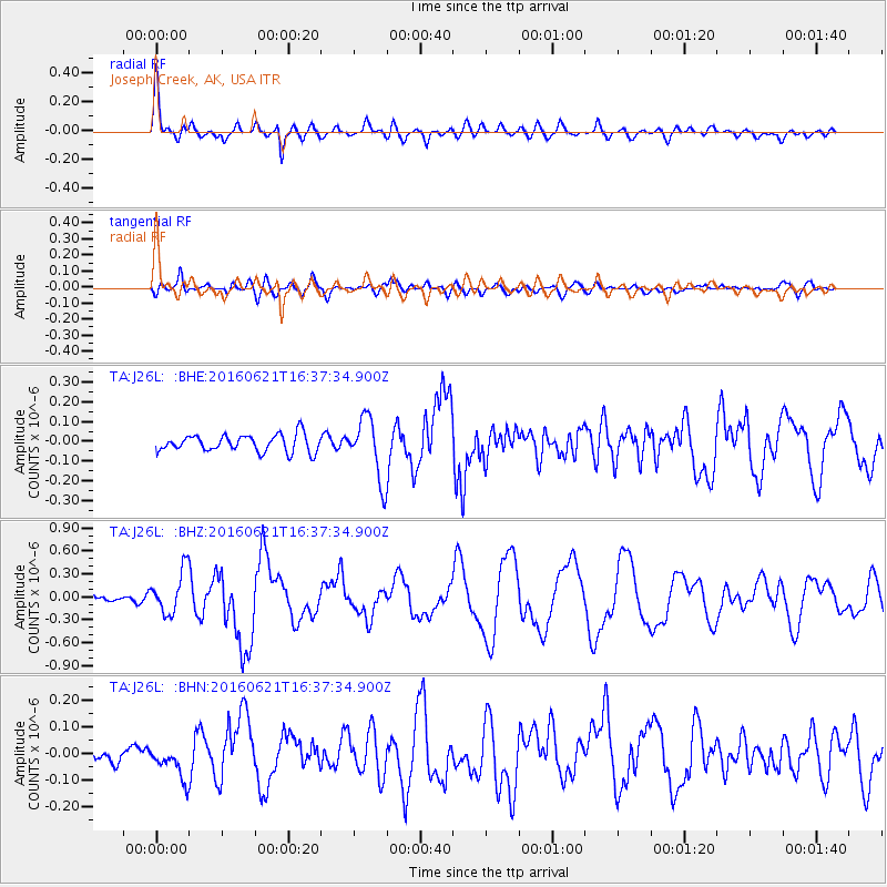
Signal To Noise
| Channel | StoN | STA | LTA |
| TA:J26L: :BHZ:20160621T16:37:34.900Z | 6.3775573 | 2.854841E-7 | 4.4763866E-8 |
| TA:J26L: :BHN:20160621T16:37:34.900Z | 2.3479354 | 7.037525E-8 | 2.9973247E-8 |
| TA:J26L: :BHE:20160621T16:37:34.900Z | 3.6140661 | 1.5612218E-7 | 4.3198487E-8 |
| Arrivals |
| Ps | 4.1 SECOND |
| PpPs | 15 SECOND |
| PsPs/PpSs | 19 SECOND |


