You are here: Home > Network List > US - United States National Seismic Network Stations List
> Station MSO Missoula, Montana, USA > Earthquake Result Viewer
MSO Missoula, Montana, USA - Earthquake Result Viewer
*The percent match for this event was below the threshold and hence no stack was calculated.
| Earthquake location: |
Taiwan Region |
| Earthquake latitude/longitude: |
24.0/122.5 |
| Earthquake time(UTC): |
2015/08/13 (225) 14:08:00 GMT |
| Earthquake Depth: |
19 km |
| Earthquake Magnitude: |
5.6 MWW, 5.4 MWB, 5.5 MWC |
| Earthquake Catalog/Contributor: |
NEIC PDE/NEIC COMCAT |
|
| Network: |
US United States National Seismic Network |
| Station: |
MSO Missoula, Montana, USA |
| Lat/Lon: |
46.83 N/113.94 W |
| Elevation: |
1264 m |
|
| Distance: |
93.0 deg |
| Az: |
34.971 deg |
| Baz: |
310.225 deg |
| Ray Param: |
$rayparam |
*The percent match for this event was below the threshold and hence was not used in the summary stack. |
|
| Radial Match: |
61.33671 % |
| Radial Bump: |
400 |
| Transverse Match: |
51.98104 % |
| Transverse Bump: |
400 |
| SOD ConfigId: |
1156111 |
| Insert Time: |
2015-09-19 15:40:56.566 +0000 |
| GWidth: |
2.5 |
| Max Bumps: |
400 |
| Tol: |
0.001 |
|
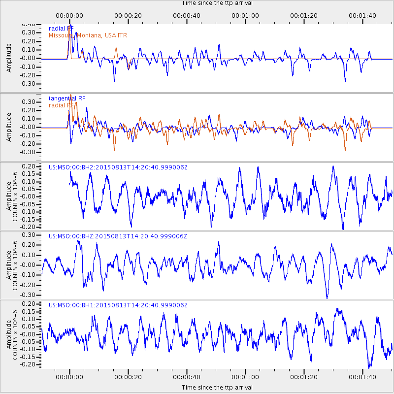
Signal To Noise
| Channel | StoN | STA | LTA |
| US:MSO:00:BHZ:20150813T14:20:40.999006Z | 2.7741137 | 1.4099194E-7 | 5.0824145E-8 |
| US:MSO:00:BH1:20150813T14:20:40.999006Z | 0.6182934 | 3.0746282E-8 | 4.972766E-8 |
| US:MSO:00:BH2:20150813T14:20:40.999006Z | 0.28596693 | 2.3430948E-8 | 8.193586E-8 |
| Arrivals |
| Ps | |
| PpPs | |
| PsPs/PpSs | |


