You are here: Home > Network List > TA - USArray Transportable Network (new EarthScope stations) Stations List
> Station N16K Nishlik Lake, AK, USA > Earthquake Result Viewer
N16K Nishlik Lake, AK, USA - Earthquake Result Viewer
| Earthquake location: |
Northern Mid-Atlantic Ridge |
| Earthquake latitude/longitude: |
22.7/-45.1 |
| Earthquake time(UTC): |
2016/06/21 (173) 16:26:34 GMT |
| Earthquake Depth: |
10 km |
| Earthquake Magnitude: |
6.1 MWB |
| Earthquake Catalog/Contributor: |
NEIC PDE/NEIC COMCAT |
|
| Network: |
TA USArray Transportable Network (new EarthScope stations) |
| Station: |
N16K Nishlik Lake, AK, USA |
| Lat/Lon: |
60.47 N/158.77 W |
| Elevation: |
582 m |
|
| Distance: |
81.4 deg |
| Az: |
332.683 deg |
| Baz: |
58.85 deg |
| Ray Param: |
0.047605734 |
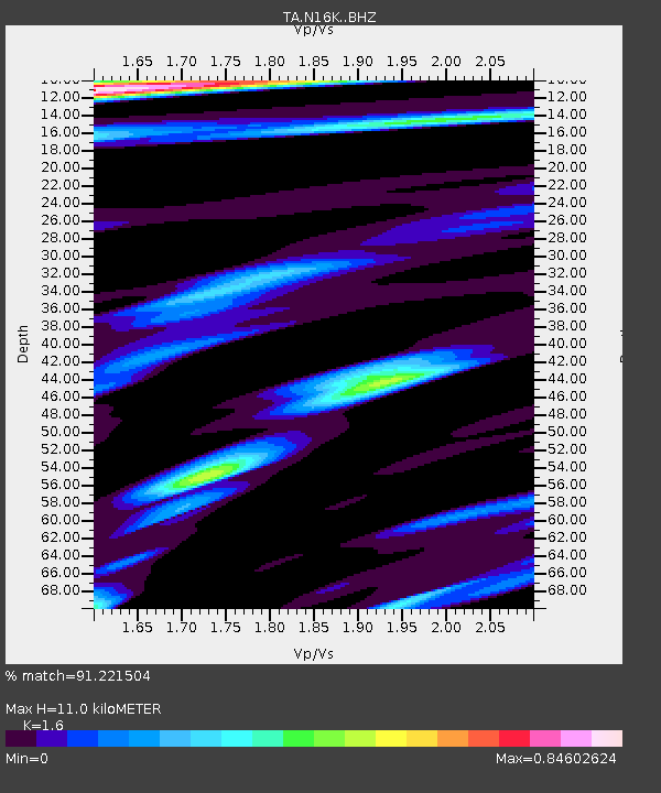
| Estimated Moho Depth: |
11.0 km |
| Estimated Crust Vp/Vs: |
1.60 |
| Assumed Crust Vp: |
6.276 km/s |
| Estimated Crust Vs: |
3.922 km/s |
| Estimated Crust Poisson's Ratio: |
0.18 |
|
| Radial Match: |
91.221504 % |
| Radial Bump: |
400 |
| Transverse Match: |
75.25719 % |
| Transverse Bump: |
400 |
| SOD ConfigId: |
7422571 |
| Insert Time: |
2019-04-22 21:42:17.599 +0000 |
| GWidth: |
2.5 |
| Max Bumps: |
400 |
| Tol: |
0.001 |
|

Signal To Noise
| Channel | StoN | STA | LTA |
| TA:N16K: :BHZ:20160621T16:38:19.975012Z | 3.7929094 | 2.9827336E-7 | 7.863973E-8 |
| TA:N16K: :BHN:20160621T16:38:19.975012Z | 1.1672859 | 8.1843524E-8 | 7.0114375E-8 |
| TA:N16K: :BHE:20160621T16:38:19.975012Z | 2.077112 | 1.6205776E-7 | 7.802071E-8 |
| Arrivals |
| Ps | 1.1 SECOND |
| PpPs | 4.4 SECOND |
| PsPs/PpSs | 5.5 SECOND |


