You are here: Home > Network List > TA - USArray Transportable Network (new EarthScope stations) Stations List
> Station P52A Corning, OH, USA > Earthquake Result Viewer
P52A Corning, OH, USA - Earthquake Result Viewer
| Earthquake location: |
Northern Mid-Atlantic Ridge |
| Earthquake latitude/longitude: |
22.7/-45.1 |
| Earthquake time(UTC): |
2016/06/21 (173) 16:26:34 GMT |
| Earthquake Depth: |
10 km |
| Earthquake Magnitude: |
6.1 MWB |
| Earthquake Catalog/Contributor: |
NEIC PDE/NEIC COMCAT |
|
| Network: |
TA USArray Transportable Network (new EarthScope stations) |
| Station: |
P52A Corning, OH, USA |
| Lat/Lon: |
39.63 N/82.13 W |
| Elevation: |
293 m |
|
| Distance: |
35.6 deg |
| Az: |
307.031 deg |
| Baz: |
107.273 deg |
| Ray Param: |
0.077134855 |
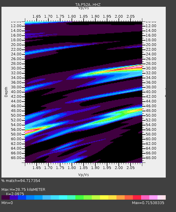
| Estimated Moho Depth: |
28.75 km |
| Estimated Crust Vp/Vs: |
2.10 |
| Assumed Crust Vp: |
6.232 km/s |
| Estimated Crust Vs: |
2.971 km/s |
| Estimated Crust Poisson's Ratio: |
0.35 |
|
| Radial Match: |
94.717354 % |
| Radial Bump: |
312 |
| Transverse Match: |
65.740234 % |
| Transverse Bump: |
400 |
| SOD ConfigId: |
7422571 |
| Insert Time: |
2019-04-22 21:42:36.777 +0000 |
| GWidth: |
2.5 |
| Max Bumps: |
400 |
| Tol: |
0.001 |
|

Signal To Noise
| Channel | StoN | STA | LTA |
| TA:P52A: :HHZ:20160621T16:33:01.250006Z | 4.6732073 | 4.9419805E-7 | 1.0575136E-7 |
| TA:P52A: :HHN:20160621T16:33:01.250006Z | 1.2558163 | 1.2694088E-7 | 1.0108236E-7 |
| TA:P52A: :HHE:20160621T16:33:01.250006Z | 2.8504076 | 3.206657E-7 | 1.1249819E-7 |
| Arrivals |
| Ps | 5.4 SECOND |
| PpPs | 13 SECOND |
| PsPs/PpSs | 19 SECOND |


