You are here: Home > Network List > TA - USArray Transportable Network (new EarthScope stations) Stations List
> Station W41B Gary Mavity, Velonia, AR, USA > Earthquake Result Viewer
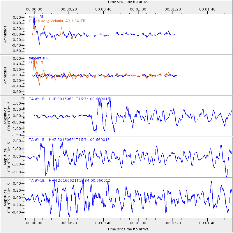
W41B Gary Mavity, Velonia, AR, USA - Earthquake Result Viewer
| Earthquake location: |
Northern Mid-Atlantic Ridge |
| Earthquake latitude/longitude: |
22.7/-45.1 |
| Earthquake time(UTC): |
2016/06/21 (173) 16:26:34 GMT |
| Earthquake Depth: |
10 km |
| Earthquake Magnitude: |
6.1 MWB |
| Earthquake Catalog/Contributor: |
NEIC PDE/NEIC COMCAT |
|
| Network: |
TA USArray Transportable Network (new EarthScope stations) |
| Station: |
W41B Gary Mavity, Velonia, AR, USA |
| Lat/Lon: |
35.17 N/92.25 W |
| Elevation: |
95 m |
|
| Distance: |
42.7 deg |
| Az: |
297.775 deg |
| Baz: |
93.943 deg |
| Ray Param: |
0.073007055 |
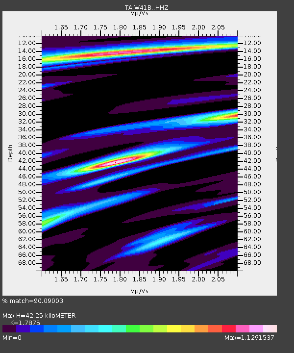
| Estimated Moho Depth: |
42.25 km |
| Estimated Crust Vp/Vs: |
1.79 |
| Assumed Crust Vp: |
6.498 km/s |
| Estimated Crust Vs: |
3.635 km/s |
| Estimated Crust Poisson's Ratio: |
0.27 |
|
| Radial Match: |
90.09003 % |
| Radial Bump: |
348 |
| Transverse Match: |
78.09995 % |
| Transverse Bump: |
400 |
| SOD ConfigId: |
7422571 |
| Insert Time: |
2019-04-22 21:42:49.435 +0000 |
| GWidth: |
2.5 |
| Max Bumps: |
400 |
| Tol: |
0.001 |
|
Signal To Noise
| Channel | StoN | STA | LTA |
| TA:W41B: :HHZ:20160621T16:34:00.66001Z | 9.607943 | 7.676318E-7 | 7.989554E-8 |
| TA:W41B: :HHN:20160621T16:34:00.66001Z | 1.5444338 | 9.2268756E-8 | 5.974277E-8 |
| TA:W41B: :HHE:20160621T16:34:00.66001Z | 6.0930147 | 4.401666E-7 | 7.2241185E-8 |
| Arrivals |
| Ps | 5.5 SECOND |
| PpPs | 17 SECOND |
| PsPs/PpSs | 22 SECOND |


