You are here: Home > Network List > UW - Pacific Northwest Regional Seismic Network Stations List
> Station LTY Liberty (broad-band) > Earthquake Result Viewer
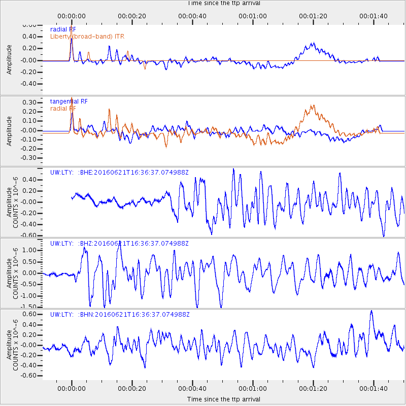
LTY Liberty (broad-band) - Earthquake Result Viewer
*The percent match for this event was below the threshold and hence no stack was calculated.
| Earthquake location: |
Northern Mid-Atlantic Ridge |
| Earthquake latitude/longitude: |
22.7/-45.1 |
| Earthquake time(UTC): |
2016/06/21 (173) 16:26:34 GMT |
| Earthquake Depth: |
10 km |
| Earthquake Magnitude: |
6.1 MWB |
| Earthquake Catalog/Contributor: |
NEIC PDE/NEIC COMCAT |
|
| Network: |
UW Pacific Northwest Regional Seismic Network |
| Station: |
LTY Liberty (broad-band) |
| Lat/Lon: |
47.26 N/120.66 W |
| Elevation: |
970 m |
|
| Distance: |
64.0 deg |
| Az: |
312.814 deg |
| Baz: |
84.128 deg |
| Ray Param: |
$rayparam |
*The percent match for this event was below the threshold and hence was not used in the summary stack. |
|
| Radial Match: |
72.16256 % |
| Radial Bump: |
400 |
| Transverse Match: |
69.55375 % |
| Transverse Bump: |
400 |
| SOD ConfigId: |
7422571 |
| Insert Time: |
2019-04-22 21:43:28.444 +0000 |
| GWidth: |
2.5 |
| Max Bumps: |
400 |
| Tol: |
0.001 |
|
Signal To Noise
| Channel | StoN | STA | LTA |
| UW:LTY: :BHZ:20160621T16:36:37.074988Z | 10.632555 | 5.246869E-7 | 4.9347207E-8 |
| UW:LTY: :BHN:20160621T16:36:37.074988Z | 2.227239 | 1.1560295E-7 | 5.1904156E-8 |
| UW:LTY: :BHE:20160621T16:36:37.074988Z | 2.191502 | 1.4179159E-7 | 6.470064E-8 |
| Arrivals |
| Ps | |
| PpPs | |
| PsPs/PpSs | |


