You are here: Home > Network List > XD14 - Illuminating the architecture of the greater Mount St. Helens magmatic systems f Stations List
> Station MC08 "Mount St Helens, WA" > Earthquake Result Viewer
MC08 "Mount St Helens, WA" - Earthquake Result Viewer
| Earthquake location: |
Northern Mid-Atlantic Ridge |
| Earthquake latitude/longitude: |
22.7/-45.1 |
| Earthquake time(UTC): |
2016/06/21 (173) 16:26:34 GMT |
| Earthquake Depth: |
10 km |
| Earthquake Magnitude: |
6.1 MWB |
| Earthquake Catalog/Contributor: |
NEIC PDE/NEIC COMCAT |
|
| Network: |
XD Illuminating the architecture of the greater Mount St. Helens magmatic systems f |
| Station: |
MC08 "Mount St Helens, WA" |
| Lat/Lon: |
46.55 N/121.96 W |
| Elevation: |
653 m |
|
| Distance: |
65.0 deg |
| Az: |
312.152 deg |
| Baz: |
82.898 deg |
| Ray Param: |
0.058553588 |
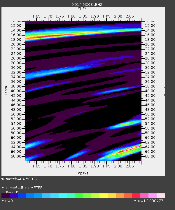
| Estimated Moho Depth: |
64.5 km |
| Estimated Crust Vp/Vs: |
2.05 |
| Assumed Crust Vp: |
6.597 km/s |
| Estimated Crust Vs: |
3.218 km/s |
| Estimated Crust Poisson's Ratio: |
0.34 |
|
| Radial Match: |
84.50827 % |
| Radial Bump: |
400 |
| Transverse Match: |
59.005554 % |
| Transverse Bump: |
400 |
| SOD ConfigId: |
7422571 |
| Insert Time: |
2019-04-22 21:44:01.880 +0000 |
| GWidth: |
2.5 |
| Max Bumps: |
400 |
| Tol: |
0.001 |
|

Signal To Noise
| Channel | StoN | STA | LTA |
| XD:MC08: :BHZ:20160621T16:36:43.355017Z | 6.9827323 | 4.0422506E-7 | 5.788924E-8 |
| XD:MC08: :BHN:20160621T16:36:43.355017Z | 1.0460085 | 8.3545885E-8 | 7.987114E-8 |
| XD:MC08: :BHE:20160621T16:36:43.355017Z | 1.8757596 | 1.2917333E-7 | 6.8864544E-8 |
| Arrivals |
| Ps | 11 SECOND |
| PpPs | 29 SECOND |
| PsPs/PpSs | 39 SECOND |


