You are here: Home > Network List > XD14 - Illuminating the architecture of the greater Mount St. Helens magmatic systems f Stations List
> Station MK08 "Mount St Helens, WA" > Earthquake Result Viewer
MK08 "Mount St Helens, WA" - Earthquake Result Viewer
| Earthquake location: |
Northern Mid-Atlantic Ridge |
| Earthquake latitude/longitude: |
22.7/-45.1 |
| Earthquake time(UTC): |
2016/06/21 (173) 16:26:34 GMT |
| Earthquake Depth: |
10 km |
| Earthquake Magnitude: |
6.1 MWB |
| Earthquake Catalog/Contributor: |
NEIC PDE/NEIC COMCAT |
|
| Network: |
XD Illuminating the architecture of the greater Mount St. Helens magmatic systems f |
| Station: |
MK08 "Mount St Helens, WA" |
| Lat/Lon: |
46.12 N/122.05 W |
| Elevation: |
762 m |
|
| Distance: |
65.1 deg |
| Az: |
311.682 deg |
| Baz: |
82.64 deg |
| Ray Param: |
0.058480136 |
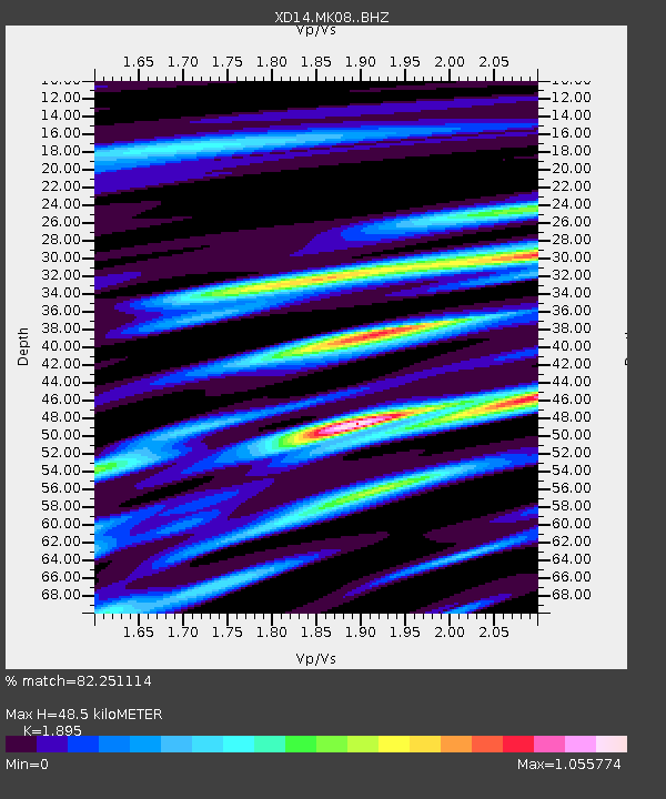
| Estimated Moho Depth: |
48.5 km |
| Estimated Crust Vp/Vs: |
1.89 |
| Assumed Crust Vp: |
6.566 km/s |
| Estimated Crust Vs: |
3.465 km/s |
| Estimated Crust Poisson's Ratio: |
0.31 |
|
| Radial Match: |
82.251114 % |
| Radial Bump: |
400 |
| Transverse Match: |
51.654667 % |
| Transverse Bump: |
400 |
| SOD ConfigId: |
7422571 |
| Insert Time: |
2019-04-22 21:44:31.958 +0000 |
| GWidth: |
2.5 |
| Max Bumps: |
400 |
| Tol: |
0.001 |
|

Signal To Noise
| Channel | StoN | STA | LTA |
| XD:MK08: :BHZ:20160621T16:36:44.079993Z | 4.3293715 | 4.2818502E-7 | 9.8902355E-8 |
| XD:MK08: :BHN:20160621T16:36:44.079993Z | 1.4393709 | 1.7484884E-7 | 1.2147588E-7 |
| XD:MK08: :BHE:20160621T16:36:44.079993Z | 1.6862425 | 1.9331611E-7 | 1.1464313E-7 |
| Arrivals |
| Ps | 6.9 SECOND |
| PpPs | 21 SECOND |
| PsPs/PpSs | 27 SECOND |


