You are here: Home > Network List > XD14 - Illuminating the architecture of the greater Mount St. Helens magmatic systems f Stations List
> Station MO07 "Mount St Helens, WA" > Earthquake Result Viewer
MO07 "Mount St Helens, WA" - Earthquake Result Viewer
| Earthquake location: |
Northern Mid-Atlantic Ridge |
| Earthquake latitude/longitude: |
22.7/-45.1 |
| Earthquake time(UTC): |
2016/06/21 (173) 16:26:34 GMT |
| Earthquake Depth: |
10 km |
| Earthquake Magnitude: |
6.1 MWB |
| Earthquake Catalog/Contributor: |
NEIC PDE/NEIC COMCAT |
|
| Network: |
XD Illuminating the architecture of the greater Mount St. Helens magmatic systems f |
| Station: |
MO07 "Mount St Helens, WA" |
| Lat/Lon: |
45.89 N/122.08 W |
| Elevation: |
1248 m |
|
| Distance: |
65.2 deg |
| Az: |
311.432 deg |
| Baz: |
82.508 deg |
| Ray Param: |
0.058442995 |
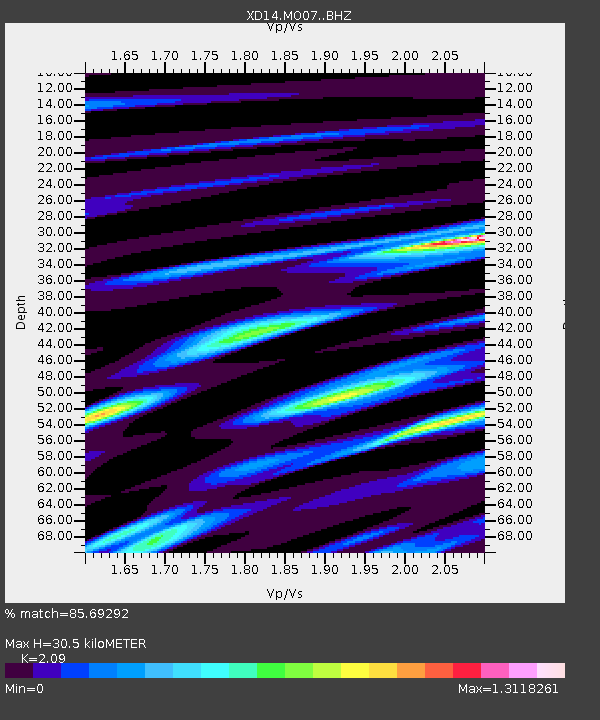
| Estimated Moho Depth: |
30.5 km |
| Estimated Crust Vp/Vs: |
2.09 |
| Assumed Crust Vp: |
6.566 km/s |
| Estimated Crust Vs: |
3.142 km/s |
| Estimated Crust Poisson's Ratio: |
0.35 |
|
| Radial Match: |
85.69292 % |
| Radial Bump: |
400 |
| Transverse Match: |
70.36202 % |
| Transverse Bump: |
400 |
| SOD ConfigId: |
7422571 |
| Insert Time: |
2019-04-22 21:44:43.138 +0000 |
| GWidth: |
2.5 |
| Max Bumps: |
400 |
| Tol: |
0.001 |
|

Signal To Noise
| Channel | StoN | STA | LTA |
| XD:MO07: :BHZ:20160621T16:36:44.454993Z | 5.537195 | 4.3900053E-7 | 7.928211E-8 |
| XD:MO07: :BHN:20160621T16:36:44.454993Z | 0.6809046 | 5.66119E-8 | 8.314219E-8 |
| XD:MO07: :BHE:20160621T16:36:44.454993Z | 2.0491717 | 1.8535434E-7 | 9.04533E-8 |
| Arrivals |
| Ps | 5.3 SECOND |
| PpPs | 14 SECOND |
| PsPs/PpSs | 19 SECOND |


