You are here: Home > Network List > TA - USArray Transportable Network (new EarthScope stations) Stations List
> Station J26L Joseph Creek, AK, USA > Earthquake Result Viewer
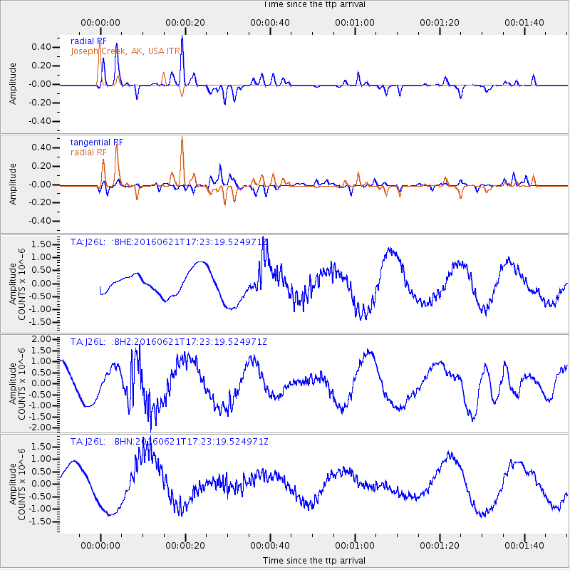
J26L Joseph Creek, AK, USA - Earthquake Result Viewer
*The percent match for this event was below the threshold and hence no stack was calculated.
| Earthquake location: |
New Ireland Region, P.N.G. |
| Earthquake latitude/longitude: |
-3.5/151.9 |
| Earthquake time(UTC): |
2016/06/21 (173) 17:12:08 GMT |
| Earthquake Depth: |
365 km |
| Earthquake Magnitude: |
6.3 MWB |
| Earthquake Catalog/Contributor: |
NEIC PDE/NEIC COMCAT |
|
| Network: |
TA USArray Transportable Network (new EarthScope stations) |
| Station: |
J26L Joseph Creek, AK, USA |
| Lat/Lon: |
64.50 N/143.56 W |
| Elevation: |
1144 m |
|
| Distance: |
82.5 deg |
| Az: |
23.227 deg |
| Baz: |
245.431 deg |
| Ray Param: |
$rayparam |
*The percent match for this event was below the threshold and hence was not used in the summary stack. |
|
| Radial Match: |
90.98988 % |
| Radial Bump: |
159 |
| Transverse Match: |
65.97008 % |
| Transverse Bump: |
324 |
| SOD ConfigId: |
7422571 |
| Insert Time: |
2019-04-22 21:49:40.296 +0000 |
| GWidth: |
2.5 |
| Max Bumps: |
400 |
| Tol: |
0.001 |
|
Signal To Noise
| Channel | StoN | STA | LTA |
| TA:J26L: :BHZ:20160621T17:23:19.524971Z | 0.6580753 | 5.5287336E-7 | 8.401369E-7 |
| TA:J26L: :BHN:20160621T17:23:19.524971Z | 1.8303756 | 1.075394E-6 | 5.875265E-7 |
| TA:J26L: :BHE:20160621T17:23:19.524971Z | 1.900247 | 8.165069E-7 | 4.296846E-7 |
| Arrivals |
| Ps | |
| PpPs | |
| PsPs/PpSs | |


